How to start saving money
Lorem ipsum dolor sit amet, consectetur adipiscing elit lobortis arcu enim urna adipiscing praesent velit viverra sit semper lorem eu cursus vel hendrerit elementum morbi curabitur etiam nibh justo, lorem aliquet donec sed sit mi dignissim at ante massa mattis.
- Neque sodales ut etiam sit amet nisl purus non tellus orci ac auctor
- Adipiscing elit ut aliquam purus sit amet viverra suspendisse potent
- Mauris commodo quis imperdiet massa tincidunt nunc pulvinar
- Excepteur sint occaecat cupidatat non proident sunt in culpa qui officia
Why it is important to start saving
Vitae congue eu consequat ac felis placerat vestibulum lectus mauris ultrices cursus sit amet dictum sit amet justo donec enim diam porttitor lacus luctus accumsan tortor posuere praesent tristique magna sit amet purus gravida quis blandit turpis.

How much money should I save?
At risus viverra adipiscing at in tellus integer feugiat nisl pretium fusce id velit ut tortor sagittis orci a scelerisque purus semper eget at lectus urna duis convallis. porta nibh venenatis cras sed felis eget neque laoreet suspendisse interdum consectetur libero id faucibus nisl donec pretium vulputate sapien nec sagittis aliquam nunc lobortis mattis aliquam faucibus purus in.
- Neque sodales ut etiam sit amet nisl purus non tellus orci ac auctor
- Adipiscing elit ut aliquam purus sit amet viverra suspendisse potenti
- Mauris commodo quis imperdiet massa tincidunt nunc pulvinar
- Adipiscing elit ut aliquam purus sit amet viverra suspendisse potenti
What percentege of my income should go to savings?
Nisi quis eleifend quam adipiscing vitae aliquet bibendum enim facilisis gravida neque. Velit euismod in pellentesque massa placerat volutpat lacus laoreet non curabitur gravida odio aenean sed adipiscing diam donec adipiscing tristique risus. amet est placerat in egestas erat imperdiet sed euismod nisi.
“Nisi quis eleifend quam adipiscing vitae aliquet bibendum enim facilisis gravida neque velit euismod in pellentesque”
Do you have any comments? Share them with us on social media
Eget lorem dolor sed viverra ipsum nunc aliquet bibendum felis donec et odio pellentesque diam volutpat commodo sed egestas aliquam sem fringilla ut morbi tincidunt augue interdum velit euismod eu tincidunt tortor aliquam nulla facilisi aenean sed adipiscing diam donec adipiscing ut lectus arcu bibendum at varius vel pharetra nibh venenatis cras sed felis eget.
Cellular GPS tracking is defined as a system that uses a GPS receiver to calculate precise location from satellite signals and a cellular modem to transmit that location data to a monitoring platform in real time. This dual-function technology is the standard method for real-time vehicle and asset monitoring across fleet management, personal vehicle security, and commercial asset protection. The GPS component handles location accuracy down to 1–5 meters. The cellular component handles communication over networks like LTE, LTE-M, and NB-IoT. Understanding how these two roles divide the work is the key to choosing the right cellular tracking system for any application.
What is cellular GPS tracking and how does it work?
Cellular GPS tracking works through two separate but connected processes: location calculation and data transmission. The GPS receiver inside a tracker listens passively to signals from multiple satellites. It uses the timing differences between those signals to calculate the device’s exact geographic coordinates. That calculation happens entirely on the device, with no data sent or received during the GPS process itself.
![]()
Once the GPS receiver has a location fix, the cellular modem takes over. It packages the coordinates, timestamp, and any additional sensor data into a small data packet. That packet travels over a cellular network to a backend server or fleet management platform, where it becomes visible as a real-time position update on a map. GPS operates as a receive-only system, which means all data consumption comes from the cellular transmission step, not the GPS reception step.
How often a tracker sends location updates is called the ping interval. A device pinging every 30 seconds uses significantly more data than one pinging every 5 minutes. For most fleet applications, a 1-minute ping interval balances real-time visibility with data cost. Tracking quality depends on GPS sampling rate, cellular network latency, and backend server responsiveness working together.
- GPS receiver: Calculates position from satellite signals. Receive-only, no data cost.
- Cellular modem: Transmits location packets to servers over LTE, LTE-M, or NB-IoT.
- Backend platform: Processes incoming data and displays it as live map positions or reports.
- Ping interval: Controls how frequently location updates are sent and directly affects data usage.
Pro Tip: Match your SIM plan to your actual ping interval. A tracker sending one update per minute uses roughly 1–5 MB per month. An IoT-specific data plan from carriers like AT&T or T-Mobile costs far less than a standard mobile plan for the same coverage.
What are the advantages of cellular GPS tracking over other methods?
GPS combined with cellular transmission is the most accurate and widely deployable tracking method available for vehicles and mobile assets. GPS accuracy sits at 1–5 meters under open sky. Cellular-only triangulation delivers 100 meters or more in dense urban areas and can reach several kilometers in rural zones. That gap makes cellular-only locating unsuitable for vehicle tracking where lane-level or street-level precision matters.
The table below compares the four main location tracking technologies across the metrics that matter most for fleet and asset managers.
| Technology | Accuracy | Coverage | Power Use | Best For |
|---|---|---|---|---|
| GPS + Cellular | 1–5 meters | Nationwide cellular coverage | Medium | Fleet tracking, real-time monitoring |
| Satellite only (GNSS) | 1–5 meters | Global | Low (receive only) | Remote areas, no cellular needed |
| Wi-Fi positioning | 15–40 meters | Indoor, urban | Low | Indoor asset tracking |
| Bluetooth | 1–10 meters | Short range (up to 100m) | Very low | Warehouse, proximity tracking |
| Cellular only | 100m to km | Nationwide | Medium | Rough location, low-cost fallback |
![]()
GPS combined with cellular wins on the combination of accuracy and coverage. Bluetooth and Wi-Fi cover specific environments well but fail the moment an asset leaves a building or campus. Satellite-only systems work globally but require separate communication hardware to report position. Cellular GPS tracking handles both jobs in one device.
The advantages of GPS tracking with cellular connectivity extend beyond accuracy:
- Wide-area coverage: Tracks vehicles across entire states or countries without infrastructure gaps.
- Real-time alerts: Geofence breaches, speeding events, and unauthorized movement trigger instant notifications.
- Low data cost: Location data packets are small, making cellular GPS trackers compatible with low-cost IoT data plans.
- Network redundancy: Devices with multi-network SIM cards switch between carriers to maintain connectivity.
The one real limitation is cellular network dependence. A tracker loses its ability to report position in areas with no cellular signal, even though the GPS receiver continues calculating location internally. Some devices store location logs locally and upload them when connectivity returns.
Which cellular networks power modern GPS trackers?
Modern GPS trackers run on three primary cellular standards, each with distinct trade-offs for power, speed, and coverage. LTE (4G) delivers the fastest data speeds and lowest latency, making it the right choice for high-frequency updates in fleet management. LTE-M (also called Cat M1) and NB-IoT are IoT-optimized standards that trade speed for dramatically lower power consumption and better signal penetration in buildings and remote areas.
LTE-M and NB-IoT modems integrating GNSS radios from manufacturers like Airgain support global connectivity with fallback to 2G networks where LTE coverage is unavailable. That fallback capability matters for fleets operating in rural regions or across international borders. The CoreLogic CL-705 module takes this further by supporting GPS, GLONASS, GALILEO, Beidou, and QZSS satellite constellations alongside LTE Cat M1, NB-IoT, and GPRS communication. Multi-constellation GNSS improves location fix reliability in urban canyons and dense tree cover.
Low-power IoT standards like LTE-M and NB-IoT have transformed GPS tracking by enabling longer battery life on smaller devices. A tracker running on NB-IoT with a duty-cycled transmission schedule can operate for months on a single battery charge. That makes wire-free asset tracking practical for trailers, equipment, and containers that lack a power source.
- LTE (4G): Best for frequent updates, low latency, hardwired vehicle trackers.
- LTE-M (Cat M1): Balanced power and speed, ideal for battery-powered vehicle trackers.
- NB-IoT: Ultra-low power, best for slow-moving or stationary assets with infrequent updates.
- 2G fallback: Maintains basic connectivity in areas where LTE coverage is absent.
Pro Tip: Choose hardware with multi-network SIM support rather than a single-carrier SIM. Multi-network SIMs automatically connect to the strongest available network, which reduces dead zones significantly for vehicles traveling across state lines or rural corridors.
How do businesses and individuals use cellular tracking for vehicles and assets?
Fleet and asset managers use cellular GPS tracking to solve four core operational problems: route inefficiency, theft, maintenance scheduling, and accountability. Real-time data improves resource allocation and theft prevention, contributing to measurable cost savings across operations of all sizes. The technology applies equally to a single-vehicle owner tracking a personal car and a logistics company managing hundreds of trucks.
Here are the most common practical applications:
-
Route optimization: Dispatchers use live position data to redirect drivers around traffic, reducing fuel costs and delivery times. Fleet management platforms like those integrated with GPS data analytics generate historical route reports that identify recurring inefficiencies.
-
Theft prevention and recovery: A geofence alert fires the moment a vehicle crosses a defined boundary outside business hours. Law enforcement can use the live position feed to recover stolen vehicles within hours rather than days.
-
Maintenance scheduling: Mileage data from cellular trackers feeds directly into maintenance logs. Fleet managers schedule oil changes, tire rotations, and inspections based on actual usage rather than calendar estimates.
-
Driver accountability: Speed alerts, harsh braking events, and idle time reports give managers objective data on driver behavior. This reduces liability exposure and lowers insurance costs over time.
-
Subscription-free asset monitoring: Businesses with tight budgets can use subscription-free GPS solutions that eliminate recurring monthly fees. This model works well for small fleets, individual contractors, and families tracking personal vehicles.
Geofencing deserves special attention as a feature. A geofence is a virtual boundary drawn on a map. When a tracked asset enters or exits that boundary, the platform sends an alert by SMS, email, or push notification. For a contractor fleet, this means knowing the moment a vehicle leaves a job site after hours. For a parent, it means knowing when a teen driver leaves school. The cellular network delivers that alert within seconds of the boundary crossing.
Key takeaways
Cellular GPS tracking combines GPS satellite positioning with cellular data transmission to deliver real-time location monitoring for vehicles and assets across wide geographic areas.
| Point | Details |
|---|---|
| GPS and cellular serve different roles | GPS calculates location; cellular transmits it. Confusing the two leads to wrong expectations about accuracy. |
| Accuracy advantage is significant | GPS delivers 1–5 meter accuracy versus 100+ meters for cellular-only triangulation. |
| Network choice affects battery life | LTE-M and NB-IoT extend battery life dramatically compared to standard LTE for IoT devices. |
| Data costs are low | Location packets are small; a tracker pinging every minute uses only 1–5 MB per month. |
| Applications span fleet and personal use | Route optimization, theft prevention, geofencing, and maintenance scheduling all rely on the same core technology. |
Why most people misunderstand cellular GPS tracking
The single biggest misconception I see is treating GPS accuracy and cellular connectivity as the same thing. They are not. GPS gives you the precise location fix. Cellular gives you the communication channel. A tracker with excellent GPS hardware but poor cellular coverage will still show gaps on the map. A tracker on a fast LTE network but with a slow GPS sampling rate will show smooth movement that lags reality by 30 seconds or more. Both components have to perform well for the system to work as expected.
What I find underappreciated is how much the backend software shapes the experience. Two trackers using identical GPS chips and the same LTE-M network can feel completely different because one platform processes and renders location updates in under a second while the other batches them every 30 seconds. When evaluating cellular tracking systems, the platform’s server responsiveness matters as much as the hardware specs. Most buyers never ask about it.
The shift toward LTE-M adoption is the most important trend in GPS tracking technology right now. Devices that previously required hardwired power connections can now run on battery for months. That opens up tracking for trailers, shipping containers, construction equipment, and any asset that moves irregularly. For businesses that have avoided GPS tracking because of installation complexity or subscription costs, the combination of LTE-M hardware and subscription-free tracking models removes both barriers at once.
My recommendation: before buying any tracker, confirm which cellular networks the hardware supports, what the platform’s average update latency is, and whether the SIM plan is IoT-specific or a repurposed mobile plan. Those three questions separate the systems that work reliably from the ones that disappoint in the field.
— Louis
Motowatchdog’s subscription-free 4G cellular GPS tracking
Motowatchdog builds 4G cellular GPS tracking devices for businesses and individuals who want real-time monitoring without a monthly subscription fee. Over 1,000 businesses rely on Motowatchdog for vehicle and asset tracking that includes customizable geofencing alerts, detailed mileage reporting, and long battery life on portable units.
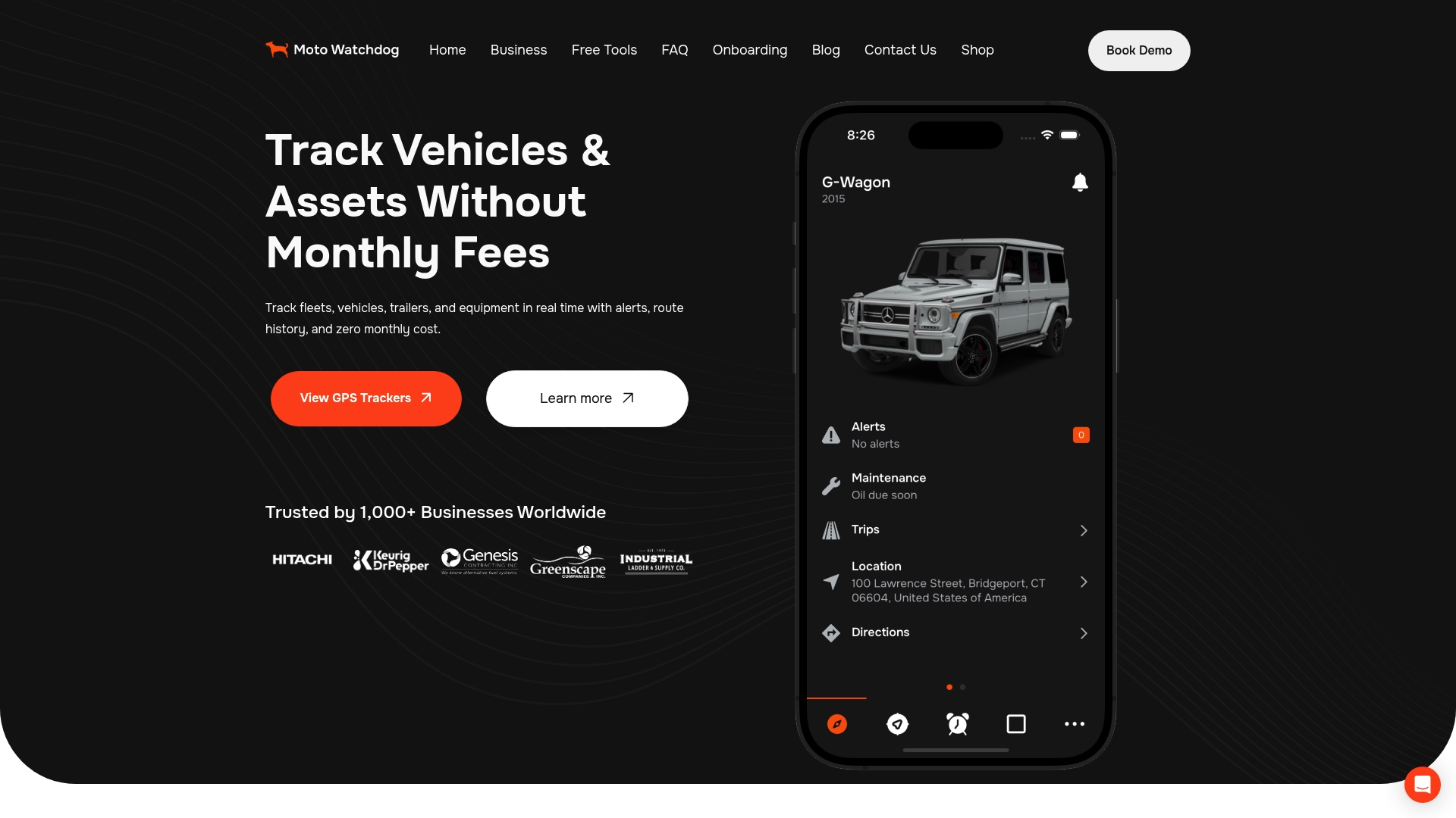
The technology behind Motowatchdog devices uses the same LTE cellular networks and GNSS positioning described in this article, delivered through a platform built for ease of setup and daily use. Whether you manage a contractor fleet or want to monitor a single vehicle, Motowatchdog’s subscription-free 4G GPS tracking gives you the real-time data you need without the ongoing cost that makes traditional fleet tracking prohibitive for smaller operations.
FAQ
What is GPS tracking in simple terms?
GPS tracking is the use of satellite signals to calculate a device’s location and report that position to a monitoring platform. In cellular GPS trackers, a cellular modem transmits the location data over a mobile network in real time.
How does cellular GPS work differently from regular GPS?
Standard GPS only calculates position. Cellular GPS adds a cellular modem that transmits that position to a server or app, enabling remote real-time monitoring. Without the cellular component, a GPS device can only log location locally.
What cellular networks do GPS trackers use?
Most modern GPS trackers use LTE, LTE-M (Cat M1), or NB-IoT networks, with 2G as a fallback for rural coverage. LTE-M and NB-IoT are preferred for battery-powered devices because they consume significantly less power than standard LTE.
Is cellular GPS tracking accurate enough for vehicle monitoring?
GPS accuracy of 1–5 meters is more than sufficient for vehicle tracking. The cellular network does not affect GPS accuracy. It only affects how quickly the calculated position reaches the monitoring platform.
What is the difference between cellular GPS tracking and cell tower tracking?
Cellular GPS tracking uses GPS satellites for precise location and cellular networks only for data transmission. Cell tower tracking estimates position from signal strength between towers, which delivers accuracy of 100 meters or more and is not reliable for vehicle monitoring.