How to start saving money
Lorem ipsum dolor sit amet, consectetur adipiscing elit lobortis arcu enim urna adipiscing praesent velit viverra sit semper lorem eu cursus vel hendrerit elementum morbi curabitur etiam nibh justo, lorem aliquet donec sed sit mi dignissim at ante massa mattis.
- Neque sodales ut etiam sit amet nisl purus non tellus orci ac auctor
- Adipiscing elit ut aliquam purus sit amet viverra suspendisse potent
- Mauris commodo quis imperdiet massa tincidunt nunc pulvinar
- Excepteur sint occaecat cupidatat non proident sunt in culpa qui officia
Why it is important to start saving
Vitae congue eu consequat ac felis placerat vestibulum lectus mauris ultrices cursus sit amet dictum sit amet justo donec enim diam porttitor lacus luctus accumsan tortor posuere praesent tristique magna sit amet purus gravida quis blandit turpis.

How much money should I save?
At risus viverra adipiscing at in tellus integer feugiat nisl pretium fusce id velit ut tortor sagittis orci a scelerisque purus semper eget at lectus urna duis convallis. porta nibh venenatis cras sed felis eget neque laoreet suspendisse interdum consectetur libero id faucibus nisl donec pretium vulputate sapien nec sagittis aliquam nunc lobortis mattis aliquam faucibus purus in.
- Neque sodales ut etiam sit amet nisl purus non tellus orci ac auctor
- Adipiscing elit ut aliquam purus sit amet viverra suspendisse potenti
- Mauris commodo quis imperdiet massa tincidunt nunc pulvinar
- Adipiscing elit ut aliquam purus sit amet viverra suspendisse potenti
What percentege of my income should go to savings?
Nisi quis eleifend quam adipiscing vitae aliquet bibendum enim facilisis gravida neque. Velit euismod in pellentesque massa placerat volutpat lacus laoreet non curabitur gravida odio aenean sed adipiscing diam donec adipiscing tristique risus. amet est placerat in egestas erat imperdiet sed euismod nisi.
“Nisi quis eleifend quam adipiscing vitae aliquet bibendum enim facilisis gravida neque velit euismod in pellentesque”
Do you have any comments? Share them with us on social media
Eget lorem dolor sed viverra ipsum nunc aliquet bibendum felis donec et odio pellentesque diam volutpat commodo sed egestas aliquam sem fringilla ut morbi tincidunt augue interdum velit euismod eu tincidunt tortor aliquam nulla facilisi aenean sed adipiscing diam donec adipiscing ut lectus arcu bibendum at varius vel pharetra nibh venenatis cras sed felis eget.
Off-road GPS tracker features are the specific hardware and software capabilities that determine whether a device keeps you safe and on course in remote terrain. The most critical types of off-road GPS tracker features include rugged construction ratings, preloaded topographic maps, multi-GNSS satellite positioning, and satellite communication for emergencies. Devices like the Garmin Tread 2, Garmin Montana 710i, and apps like onX Offroad each approach these capabilities differently. Understanding which features matter most for your adventure type is the difference between a confident trail run and a dangerous situation with no signal and no map.
1. What durability and ruggedness features should off-road GPS trackers have?
Ruggedness is the first filter for any off-road GPS device. A unit that fails from mud, rain, or vibration is worse than no unit at all because you may rely on it until the moment it stops working.
The two ratings that matter most are IP67/IPX7 water and dust resistance and MIL-STD 810 shock resistance. IP67 means the device survives submersion in up to one meter of water for 30 minutes. MIL-STD 810 means it has passed military-grade testing for vibration, shock, temperature extremes, and humidity.
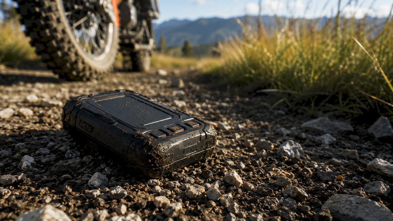
Dedicated off-road GPS units outperform smartphones in vibration, shock, and moisture resistance even when phones are in protective cases. A smartphone case adds bulk but does not add a high-sensitivity GNSS antenna or a screen calibrated for direct sunlight. The Garmin Tread 2 Overland Edition carries both IP6X dust and IPX7 water ratings, making it one of the most weather-resistant navigators in its class.
Key ruggedness features to verify before buying:
- IP67 or IPX7 water resistance for rain, stream crossings, and mud spray
- MIL-STD 810 certification for shock, vibration, and temperature extremes
- Reinforced housing with rubberized bumpers to absorb trail impacts
- Glove-friendly touchscreen that responds without bare fingers
- Heavy-duty mounting hardware rated for vehicle vibration over long trails
Pro Tip: Check whether the device’s USB port and SD card slot have sealed covers. Exposed ports are the most common failure point on otherwise rugged units.
2. Which navigation and mapping features enhance off-road GPS usability?
Navigation quality separates a trail-ready GPS from a road navigation device repurposed for dirt. The core difference is offline topographic data combined with trail-specific overlays.
Preloaded topographic and public land maps are the baseline requirement for off-road navigation. These maps show elevation contours, land ownership boundaries, and trail routes that standard road maps omit entirely. The Garmin Montana 710i uses OpenStreetMap-based TopoActive maps that include detailed trail data, public land boundaries, and an optional offline satellite imagery subscription. That combination gives you both vector trail data and visual terrain context in one device.
Screen size and brightness directly affect usability on the trail. Common screens range from 5 to 8 inches for dedicated off-road units. Larger screens reduce the need to zoom and pan while driving, which matters when you are managing a vehicle on technical terrain. The Garmin Tread 2 uses an 8-inch ultrabright touchscreen with a 1280x800 resolution that stays readable in direct sunlight.
Multi-GNSS support using GPS, GLONASS, and Galileo improves position accuracy in canyons, dense forest, and steep terrain where a single satellite system loses signal. Galileo, operated by the European Union, adds satellite coverage that fills gaps in GPS-only positioning. Devices with 10 Hz GNSS update rates refresh your position ten times per second, which matters when you are moving fast on a trail.
Offline navigation depends on pre-downloading maps before you leave cellular coverage. Failure to preload comprehensive map tiles means your GPS loses functionality the moment you go off-grid. Premium tiers on apps like onX Offroad allow unlimited map downloads. Free tiers often restrict download size, which creates gaps in coverage on longer routes.
Pro Tip: Download maps for a 50-mile radius beyond your planned route. Trails change, detours happen, and having buffer coverage costs nothing but a few minutes of prep.
3. How do connectivity and communication features impact off-road GPS functionality?
Connectivity features determine whether your GPS tracker is a navigation-only tool or a full safety system. The distinction matters most when something goes wrong far from cell coverage.
Satellite communication integration, such as Garmin inReach compatibility, provides SOS messaging and two-way text communication independent of any cellular network. The Garmin Tread 2 pairs directly with inReach devices via Bluetooth, letting you send a distress signal from the navigator’s screen without switching devices. That integration is the single most important safety feature for remote off-road travel.
Core connectivity features worth evaluating:
- Satellite SOS capability via Iridium or similar networks for emergency signaling without cell signal
- Bluetooth pairing with smartphones for live weather, notifications, and app sync
- Real-time tracking and check-in so a contact at home can monitor your position
- Wi-Fi connectivity for map and software updates at camp or home
- ANT+ sensor compatibility for tire pressure monitors and other vehicle sensors
Real-time tracking and check-in features let you send a pre-set “I’m OK” message on a schedule. That function removes the need for a satellite phone on shorter trips while still giving someone at home a live position update. Bluetooth pairing with a smartphone also enables live weather overlays on some platforms, which helps you make go or no-go decisions before a storm moves in.
4. What power, storage, and installation features matter for off-road GPS trackers?
Power source and storage capacity determine how long a device works and how much map data it can hold. Both directly affect reliability on multi-day trips.
Hardwired GPS trackers draw continuous power from the vehicle and never run out of battery during use. They require professional installation but deliver uninterrupted operation for the life of the trip. Battery-powered units are portable and transfer between vehicles easily, but runtime is limited and recharging in the field requires a power bank or solar panel.
| Feature | Hardwired GPS | Battery-Powered GPS |
|---|---|---|
| Power source | Vehicle electrical system | Internal battery or USB |
| Runtime | Unlimited while vehicle runs | Limited, typically 4–20 hours |
| Installation | Professional install required | Plug-and-play or mount |
| Portability | Fixed to one vehicle | Moves between vehicles |
| Best use case | Dedicated off-road vehicle | Multi-vehicle or hiking use |
Storage capacity determines how many maps you can carry. The Garmin Tread 2 Overland Edition offers 64GB of internal storage plus support for a 256GB microSD card. That combination holds detailed topographic maps for an entire region without requiring selective downloads. Devices with only 8–16GB of internal storage force you to manage map libraries carefully, which adds friction before every trip.
Pro Tip: Use a no-fee GPS tracker for vehicle monitoring alongside a dedicated navigation unit. Each device does one job well, and you avoid the compromises of trying to combine both functions in a single product.
5. Comparison of top off-road GPS tracker features across popular models and apps
Choosing between dedicated GPS hardware and a mobile app comes down to your use case, budget, and how remote your trips get. Each option has real strengths and real limits.
| Feature | Garmin Tread 2 | Garmin Montana 710i | onX Offroad App |
|---|---|---|---|
| Screen size | 8 inches | 7 inches | Phone-dependent |
| Water resistance | IP6X/IPX7 | IPX7 | Phone-dependent |
| MIL-STD 810 | Yes | Yes | No |
| Offline maps | Preloaded topo + SD | TopoActive + satellite imagery | Download required |
| Satellite SOS | Via inReach pairing | Via inReach pairing | No |
| Multi-GNSS | GPS, Galileo, 10 Hz | GPS, Galileo | Phone GPS only |
| Storage | 64GB + 256GB SD | Internal + SD | Cloud + phone storage |
| Power | Hardwired or battery | Battery | Phone battery |
The Garmin Tread 2 is the strongest choice for vehicle-mounted navigation on dedicated off-road rigs. Its 8-inch screen, hardwired power option, and inReach compatibility make it a full safety system. The Montana 710i suits riders who move between vehicles or use the device on foot, since its smaller form factor and battery power give it more flexibility. The onX Offroad app works well as a supplemental tool for trail discovery and community-sourced route data, but it depends entirely on your phone’s durability and battery life.
Key differences that affect the buying decision:
- The Tread 2 is the only option with a vehicle-grade mounting system and an 8-inch display
- The Montana 710i’s TopoActive maps include public land boundaries that the app requires a paid subscription to access
- onX Offroad offers the largest community-sourced trail database but provides no hardware ruggedness guarantee
- GPS and dashcam integration on smartphones adds navigation context to video footage, but dedicated units remain more reliable in extreme conditions
Key takeaways
The most reliable off-road GPS setup combines a rugged dedicated device with preloaded offline maps, multi-GNSS positioning, and satellite communication capability.
| Point | Details |
|---|---|
| Ruggedness ratings matter | Verify IP67/IPX7 and MIL-STD 810 ratings before buying any off-road GPS device. |
| Offline maps are non-negotiable | Pre-download topographic, satellite, and trail tiles before leaving cell coverage. |
| Multi-GNSS improves accuracy | GPS plus Galileo or GLONASS fills positioning gaps in canyons and dense terrain. |
| Satellite SOS adds critical safety | Garmin inReach integration enables emergency messaging with no cell signal required. |
| Power source shapes reliability | Hardwired units run indefinitely; battery units need a recharge plan for multi-day trips. |
What I’ve learned about picking off-road GPS features that actually matter
Most people shopping for an off-road GPS focus on screen size and brand name. Those things matter, but they are not what saves you when a trail disappears into a wash at dusk.
The feature I never compromise on is offline satellite communication. I have been in canyons where the topo map was perfect and the trail was exactly where it should be, but a mechanical issue turned a navigation problem into an emergency. A device that can send an SOS via Iridium satellite is not a luxury for remote trips. It is the only feature that matters when everything else goes wrong.
The second thing I have learned is that offline map quality varies enormously between devices. The Garmin Montana 710i’s TopoActive maps include public land boundaries that show you exactly where you can legally camp or recover a vehicle. That detail sounds minor until you are trying to figure out if the flat ground ahead is BLM land or private property at 9 PM.
My honest recommendation: buy the most rugged dedicated unit your budget allows, pair it with a subscription-free GPS solution for vehicle tracking, and treat your phone app as a backup, not a primary navigator. The adventurers who get into trouble are almost always the ones who trusted a phone screen in a situation that called for a dedicated device.
— Louis
How Motowatchdog supports off-road vehicle tracking
Motowatchdog delivers subscription-free 4G GPS tracking built for vehicle owners who need real-time location monitoring without paying monthly fees. For off-road enthusiasts, that means continuous vehicle tracking during trail runs, recovery operations, and multi-vehicle convoys without a recurring cost eating into your gear budget. Over 1,000 businesses rely on Motowatchdog’s accuracy for fleet monitoring. The same reliability applies to individual off-road rigs.
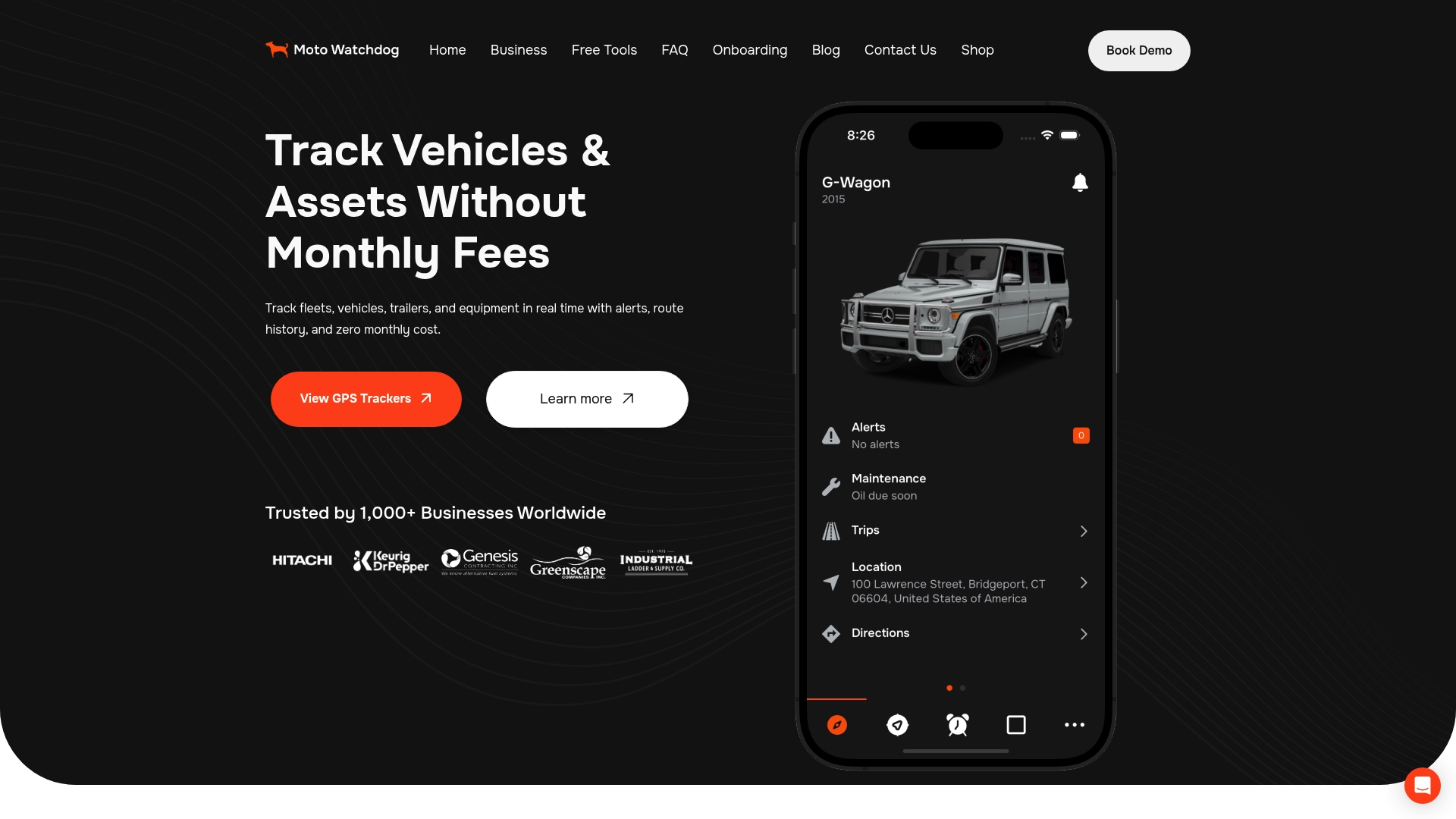
Motowatchdog’s geofencing alerts notify you when a vehicle leaves a defined area, which is useful for staging vehicles at a trailhead while you explore on foot. Detailed mileage tracking also simplifies maintenance scheduling for high-use off-road vehicles. Explore Motowatchdog’s full feature set to find the right GPS tracking solution for your rig.
FAQ
What are the most important off-road GPS tracker features?
The most critical features are IP67/IPX7 water resistance, MIL-STD 810 shock rating, preloaded offline topographic maps, multi-GNSS positioning, and satellite SOS communication. These five capabilities cover durability, navigation, and emergency safety in remote terrain.
Can I use a smartphone app instead of a dedicated off-road GPS?
Smartphone apps like onX Offroad work well for trail discovery and supplemental navigation, but dedicated GPS units outperform phones in shock resistance, moisture protection, and GNSS sensitivity. For remote or technical terrain, a dedicated device is the more reliable choice.
What is multi-GNSS and why does it matter for off-roading?
Multi-GNSS means a device connects to multiple satellite systems such as GPS, GLONASS, and Galileo simultaneously. That combination improves position accuracy in canyons, dense forest, and steep terrain where a single satellite system loses reliable signal.
What is the difference between hardwired and battery-powered GPS trackers?
Hardwired GPS trackers draw power from the vehicle’s electrical system and run continuously without battery limits. Battery-powered units are portable and easier to move between vehicles but require recharging, which limits runtime on extended trips.
Do off-road GPS devices work without cell service?
Yes. Dedicated off-road GPS devices use satellite-based GNSS positioning that operates independently of cellular networks. Devices with preloaded offline maps and satellite communication features like Garmin inReach provide full navigation and emergency messaging with no cell signal required.