How to start saving money
Lorem ipsum dolor sit amet, consectetur adipiscing elit lobortis arcu enim urna adipiscing praesent velit viverra sit semper lorem eu cursus vel hendrerit elementum morbi curabitur etiam nibh justo, lorem aliquet donec sed sit mi dignissim at ante massa mattis.
- Neque sodales ut etiam sit amet nisl purus non tellus orci ac auctor
- Adipiscing elit ut aliquam purus sit amet viverra suspendisse potent
- Mauris commodo quis imperdiet massa tincidunt nunc pulvinar
- Excepteur sint occaecat cupidatat non proident sunt in culpa qui officia
Why it is important to start saving
Vitae congue eu consequat ac felis placerat vestibulum lectus mauris ultrices cursus sit amet dictum sit amet justo donec enim diam porttitor lacus luctus accumsan tortor posuere praesent tristique magna sit amet purus gravida quis blandit turpis.

How much money should I save?
At risus viverra adipiscing at in tellus integer feugiat nisl pretium fusce id velit ut tortor sagittis orci a scelerisque purus semper eget at lectus urna duis convallis. porta nibh venenatis cras sed felis eget neque laoreet suspendisse interdum consectetur libero id faucibus nisl donec pretium vulputate sapien nec sagittis aliquam nunc lobortis mattis aliquam faucibus purus in.
- Neque sodales ut etiam sit amet nisl purus non tellus orci ac auctor
- Adipiscing elit ut aliquam purus sit amet viverra suspendisse potenti
- Mauris commodo quis imperdiet massa tincidunt nunc pulvinar
- Adipiscing elit ut aliquam purus sit amet viverra suspendisse potenti
What percentege of my income should go to savings?
Nisi quis eleifend quam adipiscing vitae aliquet bibendum enim facilisis gravida neque. Velit euismod in pellentesque massa placerat volutpat lacus laoreet non curabitur gravida odio aenean sed adipiscing diam donec adipiscing tristique risus. amet est placerat in egestas erat imperdiet sed euismod nisi.
“Nisi quis eleifend quam adipiscing vitae aliquet bibendum enim facilisis gravida neque velit euismod in pellentesque”
Do you have any comments? Share them with us on social media
Eget lorem dolor sed viverra ipsum nunc aliquet bibendum felis donec et odio pellentesque diam volutpat commodo sed egestas aliquam sem fringilla ut morbi tincidunt augue interdum velit euismod eu tincidunt tortor aliquam nulla facilisi aenean sed adipiscing diam donec adipiscing ut lectus arcu bibendum at varius vel pharetra nibh venenatis cras sed felis eget.
Location history for heavy equipment is the time-stamped record of every position, movement, and stop a machine makes, turning raw GPS coordinates into operational evidence your team can act on. The three outcomes that matter most: tracked assets recover much faster after theft compared to multi-week investigations without GPS, utilization gaps become visible enough to right-size your fleet, and engine-hour correlation triggers maintenance before a breakdown costs you a shift.
Three actions to take before you read further:
- Audit your assets by replacement value and theft risk, then rank them for device priority.
- Identify your highest-risk machines (excavators, skid steers, generators) and equip those first.
- Enable after-hours geofencing on every tracked asset before the first weekend.
Table of Contents
- How does GPS location history actually get collected and stored?
- What features should you require from a location-history system?
- Practical uses of heavy equipment location history every day
- How to roll out location-history tracking across your fleet
- How do you choose the right location-history solution for your fleet?
- Key Takeaways
- What location history taught me about running a tighter fleet
- No monthly fees, full location history: Motowatchdog for equipment fleets
- Useful sources and further reading
How does GPS location history actually get collected and stored?
The hardware choice determines what your location history contains and how many gaps it has. Device architecture should match the asset class: hardwired cellular trackers for powered heavy equipment (excavators, dozers, motor graders), battery-powered cellular units for non-powered assets (trailers, attachments, compactors), and BLE tags feeding a gateway mesh for yard-level inventory where precise outdoor GPS is less critical.
Connectivity tier shapes history granularity just as much as the device itself. LTE-M and NB-IoT are the workhorses for most construction sites, offering low-power, wide-area coverage that keeps reporting intervals tight without draining a battery pack. Satellite connectivity is the right call for remote forestry, mining, or pipeline sites where cellular coverage is absent, though it typically means longer reporting intervals and higher per-message costs.
| Asset Type | Recommended Device | Connectivity | Rationale |
|---|---|---|---|
| Excavator, dozer, grader | Hardwired cellular | LTE-M / NB-IoT | Continuous power; frequent reporting; engine-hour correlation |
| Trailer, attachment | Battery-powered cellular | LTE-M | No power source; motion-triggered pings conserve battery |
| Yard equipment, small tools | BLE tag + gateway | BLE mesh | Short-range; gateway aggregates and uploads |
| Remote mining / forestry | Hardwired satellite | Satellite | No cellular; accepts longer reporting intervals |
On-device logging is what saves you when connectivity drops. A quality tracker stores positions locally and uploads the full sequence once signal returns, so your playback timeline stays continuous rather than showing a blank stretch across a dead zone. Cloud ingestion then organizes those records into the playback interface, heat maps, and CSV exports your team uses for billing and investigations.
Accuracy outdoors with multi-constellation GNSS (GPS + GLONASS + Galileo) runs 2–5 meters under open sky, which is precise enough for geofence triggers and route playback. GPS drift near site structures or tree cover is a known source of false-positive alerts; the fix is a geofence buffer of at least 50–100 meters combined with a secondary confirmation signal (ignition state or accelerometer) before an alert fires.
GPS guidance systems in earthmoving have integrated position data with machine control for decades, which is why modern trackers can correlate location with engine state rather than treating them as separate data streams.
What features should you require from a location-history system?
Not every GPS tracker delivers the same depth of history. The features below are the ones that convert a location dot into evidence a manager, auditor, or law enforcement officer can use.
| Feature | Operational Purpose | Minimum Spec to Require |
|---|---|---|
| After-hours geofence alerts | Instant theft notification | Configurable time windows; SMS + push |
| Tamper / tow detection | Catches removal before the machine leaves the site | Accelerometer trigger + immediate alert |
| Motion-triggered reporting | Preserves battery; captures movement start | Configurable sensitivity threshold |
| Engine-hour correlation | Ties location to actual runtime for maintenance | Ignition or CAN-bus input |
| Historical playback | Reconstructs routes for investigations and billing | 90-day minimum retention; 1-minute resolution |
| Exportable audit trails | Supports invoices, change orders, compliance | CSV / PDF export with timestamps |
| Configurable retention windows | Meets project or legal record-keeping needs | User-adjustable; 12-month preferred |
| Event timestamping | Precise start/stop records for billing | UTC-synced; no rounding |
Three of these features carry disproportionate weight for security-focused fleets. Tamper detection catches a theft attempt before the machine clears the fence. After-hours geofencing paired with instant alerts gives law enforcement a head start measured in minutes, not days. Historical playback then provides the direction-of-travel and timestamp sequence investigators need to coordinate a recovery.
For utilization-focused fleets, engine-hour correlation and exportable audit trails do the heavy lifting. A machine that shows up on a heat map but never logs ignition-on hours is a candidate for reallocation or sale. Exportable records with event timestamps let project managers verify on-site time against invoices without a phone call.
Telematics platforms that combine GPS with engine hours and fault codes create maintenance triggers that a pure location tracker cannot, which is why specifying engine-hour correlation at purchase time matters.
Practical uses of heavy equipment location history every day
Theft prevention and recovery
Close to 1,000 pieces of construction equipment are stolen every month in the U.S., and the recovery rate without GPS tracking is low (around 20%). With a tracked machine, the recovery window compresses from weeks to 24–48 hours because investigators receive a timestamped movement trail rather than a last-known-location guess.
The sequence that works: an after-hours geofence fires an alert the moment the machine moves, the alert goes simultaneously to the site manager and a designated law enforcement contact, and the historical trace provides direction of travel and intermediate stops. Police can intercept rather than search.
Pro Tip: Set two geofence layers: a tight inner fence at the machine’s parking spot and a wider outer fence at the site perimeter. The inner fence catches a move; the outer fence confirms the machine has left the site. Two triggers eliminate almost all false positives from GPS drift.
Visible tracking indicators, such as stickers and external antennae, act as deterrents before a theft attempt even begins. Deterrence plus rapid-response geofencing is more cost-effective than relying on recovery alone.
Utilization and right-sizing
Aggregated location-history traces build utilization heat maps that reveal machines sitting on-site but never moving or powering on. Those assets are candidates for reallocation to a busier project or for sale. A fleet manager who reviews 90 days of heat maps before a rental renewal can often eliminate one or two redundant machines, which pays for the entire tracking program.

Movement history also supports buy-versus-rent decisions. If a machine logs fewer than 40 hours per month across multiple projects, renting on demand is almost always cheaper than ownership and maintenance.
Maintenance and predictive workflows
Predictive maintenance models using telematics data provide high forecasting accuracy, surfacing component risk well in advance of failure. The input is straightforward: engine hours from the tracker trigger a service window, and fault codes from CAN-bus-connected devices flag abnormal operating conditions before they become breakdowns.

Correlating location history with engine hours also catches machines running at idle for extended periods, which accelerates wear without productive output. Flagging chronic idlers for operator coaching reduces both fuel consumption and maintenance frequency.
Billing, project verification, and compliance
Location playback is the fastest way to resolve a disputed invoice. A subcontractor claiming 10 hours on-site can be verified against the machine’s timestamped arrival and departure records in under two minutes. The same export supports change-order documentation, lien waivers, and equipment-use logs required by some public contracts.
How to roll out location-history tracking across your fleet
A phased rollout prevents the two most common mistakes: buying identical devices for assets with different needs, and deploying everything at once without validating alert thresholds.
- Complete an asset inventory. List every machine by class, replacement value, theft-risk rating (based on size, portability, and site exposure), and whether it has a constant power source.
- Rank assets for device priority. Equip high-value, high-theft-risk, frequently moved machines first: excavators, skid steers, compact track loaders, and generators before trailers and attachments.
- Select device types by asset class. Use the architecture table in the “How does GPS location history get collected” section above as your guide. Hardwired units for powered equipment; battery-powered for non-powered assets.
- Plan installation. Hardwired installs on a typical piece of heavy equipment take 1–2 hours per unit; battery-powered mounts take under 30 minutes. For hardwiring guidance specific to fleet equipment, follow a step-by-step wiring checklist to avoid common mistakes with ignition-sense wires.
- Configure reporting intervals, geofence buffers, and alert recipients before the device goes live. Set reporting to 1–5 minutes during active hours and motion-triggered during off-hours to balance battery life and history resolution.
- Run a 5-day validation period. Review playback for each newly installed device, tune geofence buffers to eliminate false positives, and confirm alerts reach the right people.
- Brief your law enforcement contact. Provide the precinct or county sheriff’s office with your tracking platform’s contact information and explain how to request a location trace in a theft event.
- Train operators and site supervisors. A 30-minute walkthrough covering what the tracker records, how to read a playback, and what triggers an alert is enough for most teams.
Phased timeline:
- Days 1–15: Asset audit, device procurement, and installation on Tier 1 assets (highest value/risk).
- Days 16–30: Validation, alert tuning, and law enforcement briefing.
- Days 31–60: Tier 2 installation (trailers, attachments, secondary equipment).
- Days 61–90: Full fleet live; first utilization heat map review; maintenance trigger calibration.
How do you choose the right location-history solution for your fleet?
The right solution depends on four variables: fleet size, asset mix, coverage geography, and budget model. Work through this checklist before you evaluate any device.
Buyer checklist:
- Fleet size: under 25 assets, 25–100, or 100+?
- Asset mix: powered heavy equipment only, or mixed with non-powered trailers and attachments?
- Coverage: urban/suburban sites with strong cellular, or remote sites requiring satellite?
- Data retention: project-level (90 days) or long-term compliance (12 months+)?
- Integration: does your existing fleet management software support ISO/TS 15143-3 (AEMP 2.0) for mixed-OEM telemetry ingestion?
- Budget model: one-time device purchase or ongoing subscription?
Decision guidance by fleet profile:
Small to mid-sized urban contractors (under 50 assets) benefit most from a subscription-free, cellular device. The total cost of ownership is predictable, and there are no monthly fees to justify to ownership after the first year. For small fleet cost modeling, a one-time device purchase typically pays back within the first avoided theft or eliminated rental.
Mixed-brand contractors with 50–150 assets should prioritize platforms that support ISO/TS 15143-3 so OEM telematics data from different manufacturers feeds a single dashboard. Portal-hopping across four manufacturer portals is operationally unsustainable.
Remote mining and forestry operations need satellite-capable units regardless of cost model, because cellular coverage gaps create history voids that defeat the purpose of the system.
Pro Tip: Before signing any subscription contract, calculate 36-month total cost of ownership: device cost plus monthly fees times 36. Compare that against a one-time device purchase. For fleets under 50 assets, the subscription model often costs two to three times more over three years.
Motowatchdog’s subscription-free GPS devices map directly to the small-to-mid-sized contractor profile. The devices offer real-time location tracking, customizable geofencing and alerts, long battery life, exportable trip and mileage history, maintenance reminders, and idle-time tracking, all managed through a mobile app with no recurring fees. Over 1,000 businesses rely on Motowatchdog’s accuracy, and the setup path is straightforward enough that a site supervisor can complete installation without a technician. For fleets that need quick implementation and a clear cost ceiling, that combination is hard to match.
Key Takeaways
Location history turns GPS coordinates into operational evidence: the fleets that use it systematically recover stolen equipment faster, right-size their asset pools, and reduce unplanned downtime.
| Point | Details |
|---|---|
| Theft recovery speed | Tracked assets recover within 24–48 hours; untracked equipment recovers at a low rate (around 20%). |
| After-hours geofencing | Dual-layer geofences (inner parking spot + outer site perimeter) eliminate false positives and speed law enforcement response. |
| Utilization heat maps | Aggregated location traces reveal idle assets that should be reallocated or sold before the next rental cycle. |
| Phased rollout order | Equip high-value, high-theft-risk powered assets first; validate alert thresholds before expanding to Tier 2 assets. |
| Motowatchdog fit | Subscription-free devices with geofencing, exportable history, and long battery life suit small-to-mid-sized fleets needing fast, low-cost deployment. |
What location history taught me about running a tighter fleet
The conventional wisdom in fleet management is that GPS tracking is primarily a theft tool. That framing undersells it by about 80%. Theft recovery is the headline benefit because it is the most dramatic, but the managers who get the most value from equipment location history are the ones who use it to answer a quieter question: where is my equipment actually spending its time, and is that where I need it?
The utilization heat map is the most underused feature in most tracking deployments. Fleets that review 90 days of aggregated traces before a budget cycle routinely find one or two machines that have not moved in weeks. Those machines are not generating revenue; they are generating insurance premiums, maintenance costs, and depreciation. Selling or reallocating them often funds the entire tracking program for the year.
The other thing most guides miss is the law enforcement relationship. A geofence alert at 2 AM is only as useful as your ability to act on it. Managers who have pre-briefed their local precinct, shared their platform’s contact protocol, and established a named point of contact recover equipment at a dramatically higher rate than those who call 911 cold with a GPS coordinate. That relationship takes 30 minutes to build and pays off the first time you need it.
The technology is mature and the devices are affordable. The gap between fleets that get real ROI and those that do not is almost never the hardware. It is the configuration: geofence buffers sized correctly, alert recipients who actually respond, and a monthly review habit that turns historical data into decisions.
No monthly fees, full location history: Motowatchdog for equipment fleets
Fleet managers who want complete location history without a subscription bill have a direct path: Motowatchdog’s GPS tracking devices deliver real-time positioning, customizable geofencing, long battery life, and exportable trip history for a one-time hardware cost. No monthly fees means the ROI calculation is straightforward, and the mobile app puts playback, alerts, and maintenance reminders in your pocket from day one.
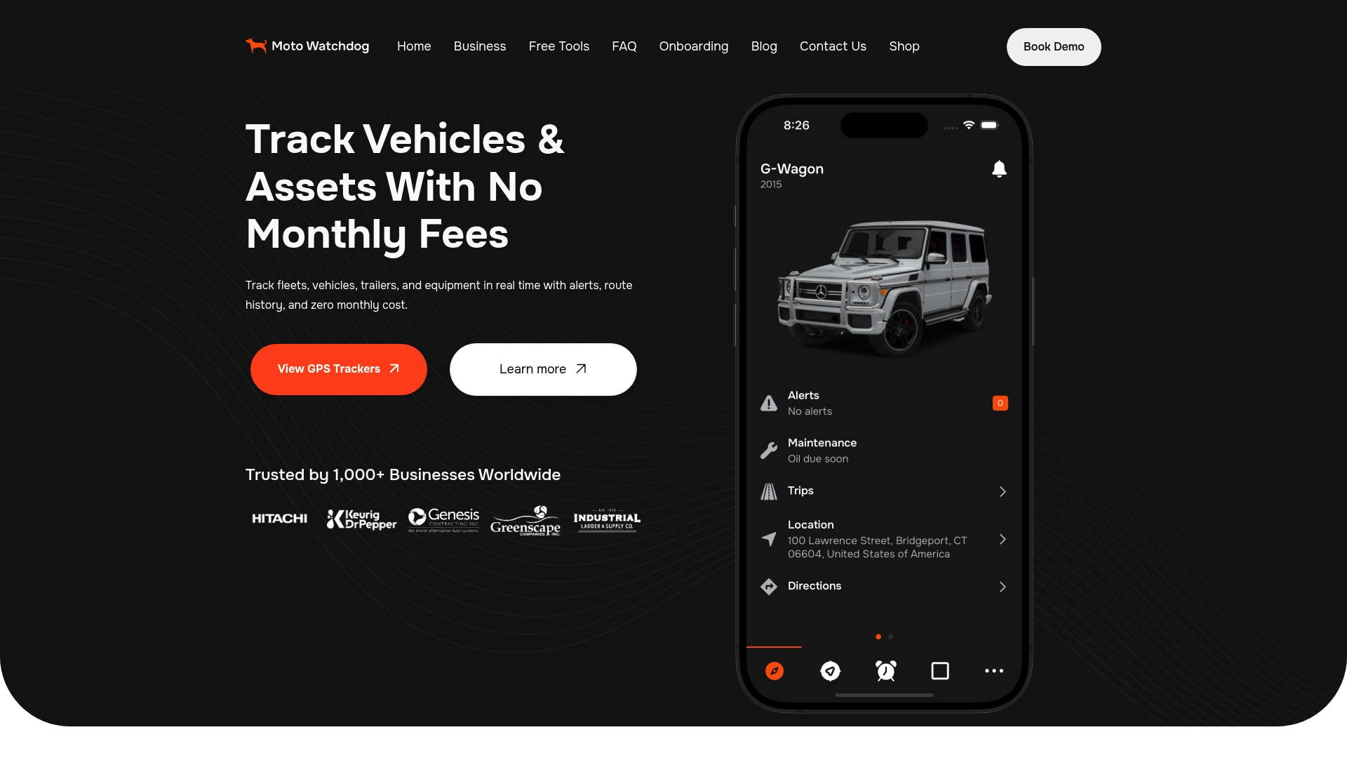
The device lineup covers powered heavy equipment and non-powered assets, with configurations suited to the hardwired and battery-powered architectures described in this guide. Geofencing, tamper alerts, idle-time tracking, and multi-device management are all included. For fleets under 50 assets that need fast deployment and a predictable cost ceiling, Motowatchdog is a practical first step. See the full device lineup and get started with subscription-free equipment tracking today.
Useful sources and further reading
The sources below are worth bookmarking depending on where you are in your rollout.
- Why Heavy Equipment Tracking Is Essential for Construction and Industrial Operations — Start here for a foundational overview of tracking benefits and operational context.
- GPS Tracking for Equipment: Where the Real ROI Hides — Detailed breakdown of device architectures, connectivity tiers, and recovery statistics; essential for procurement decisions.
- How to Prevent Theft and Increase Equipment Recovery at Construction Sites — Best-practice geofencing strategy and deterrence program design.
- Construction Equipment Tracking Software: The Complete 2026 Guide — Covers ISO/TS 15143-3 integration and mixed-fleet telematics platforms.
- GPS in the Earthmoving Industry — Technical background on GPS adoption in heavy machinery and machine-control integration.
- Motowatchdog GPS Tracker Fleet Hardwiring Guide — Step-by-step wiring instructions for powered heavy equipment; consult this before your first hardwired install.
- Subscription-Free GPS Explained for Businesses — TCO comparison and feature overview for managers evaluating one-time purchase versus subscription models.
- Fleet GPS Data Integration Examples for Fleet Managers — Practical examples of connecting tracker data to existing fleet management and dispatch systems.