How to start saving money
Lorem ipsum dolor sit amet, consectetur adipiscing elit lobortis arcu enim urna adipiscing praesent velit viverra sit semper lorem eu cursus vel hendrerit elementum morbi curabitur etiam nibh justo, lorem aliquet donec sed sit mi dignissim at ante massa mattis.
- Neque sodales ut etiam sit amet nisl purus non tellus orci ac auctor
- Adipiscing elit ut aliquam purus sit amet viverra suspendisse potent
- Mauris commodo quis imperdiet massa tincidunt nunc pulvinar
- Excepteur sint occaecat cupidatat non proident sunt in culpa qui officia
Why it is important to start saving
Vitae congue eu consequat ac felis placerat vestibulum lectus mauris ultrices cursus sit amet dictum sit amet justo donec enim diam porttitor lacus luctus accumsan tortor posuere praesent tristique magna sit amet purus gravida quis blandit turpis.

How much money should I save?
At risus viverra adipiscing at in tellus integer feugiat nisl pretium fusce id velit ut tortor sagittis orci a scelerisque purus semper eget at lectus urna duis convallis. porta nibh venenatis cras sed felis eget neque laoreet suspendisse interdum consectetur libero id faucibus nisl donec pretium vulputate sapien nec sagittis aliquam nunc lobortis mattis aliquam faucibus purus in.
- Neque sodales ut etiam sit amet nisl purus non tellus orci ac auctor
- Adipiscing elit ut aliquam purus sit amet viverra suspendisse potenti
- Mauris commodo quis imperdiet massa tincidunt nunc pulvinar
- Adipiscing elit ut aliquam purus sit amet viverra suspendisse potenti
What percentege of my income should go to savings?
Nisi quis eleifend quam adipiscing vitae aliquet bibendum enim facilisis gravida neque. Velit euismod in pellentesque massa placerat volutpat lacus laoreet non curabitur gravida odio aenean sed adipiscing diam donec adipiscing tristique risus. amet est placerat in egestas erat imperdiet sed euismod nisi.
“Nisi quis eleifend quam adipiscing vitae aliquet bibendum enim facilisis gravida neque velit euismod in pellentesque”
Do you have any comments? Share them with us on social media
Eget lorem dolor sed viverra ipsum nunc aliquet bibendum felis donec et odio pellentesque diam volutpat commodo sed egestas aliquam sem fringilla ut morbi tincidunt augue interdum velit euismod eu tincidunt tortor aliquam nulla facilisi aenean sed adipiscing diam donec adipiscing ut lectus arcu bibendum at varius vel pharetra nibh venenatis cras sed felis eget.
GPS is one satellite navigation system, owned by the United States. GNSS (Global Navigation Satellite System) is the umbrella term for all of them: GPS, Russia’s GLONASS, Europe’s Galileo and China’s BeiDou. GPS.gov describes GNSS as a general term for any satellite constellation that provides positioning, navigation and timing, with GPS the most prevalent. For a fleet or heavy equipment rental operation, the practical question is what you can count on from a tracker: where a machine is, whether it moved, and whether the position is good enough to act on. The satellites matter less than the full tracking system around them: the cellular data link, the reporting rules and the software.
A tracker with real-time location, geofencing and mileage reports and no monthly fee gives you that answer without a subscription. Our trackers start at $124.99, one time, with lifetime 4G data included.
TL;DR
- GPS is a single constellation. GNSS covers every constellation, so “GPS tracker” is often used loosely for a device that may read several systems.
- More constellations mean more satellites in view. That helps most where the sky is blocked: urban streets, deep excavations, tree lines and stacked equipment yards.
- Published government and university measurements show GNSS beating GPS-only in dense urban settings, though open-sky accuracy is already good for fleet work.
- Satellites find the position. A cellular link reports it to you, so look at the data plan as closely as at the chipset.
- Bluetooth tags are for finding things nearby. Equipment that leaves the yard needs a tracker that reports over cellular.
Table of Contents
- GPS vs GNSS in plain terms
- Do the other systems compare with GPS, and can one device use them all?
- What the accuracy numbers say
- Urban canyons and job sites: where it matters for fleets
- The part people overlook: reporting the position
- Bluetooth tags vs GPS trackers
- What to look for in a fleet tracker
- A worked example: 25 units over three years
- Perspective
- Our trackers for fleets and equipment
- FAQ
- Sources
GPS vs GNSS in plain terms
Think of GNSS as the category and GPS as one product in it. EarthScope Consortium compares it to the way a brand name can stand in for a whole product type: GPS was the first system to become widely available, in 1994, and is now one of four global constellations.
The four global systems are:
- GPS (United States)
- GLONASS (Russia)
- Galileo (European Union)
- BeiDou (China)
Regional systems add to the mix. Japan’s QZSS, for example, complements GPS over Japan and the Asia-Pacific region, according to GPS.gov.
Each system works the same way at a basic level. Satellites broadcast timed signals. A receiver on your truck, trailer or excavator listens to at least four of them, measures how long each signal took to arrive, and solves for its position. Four are needed because the receiver is solving for three position values plus its own clock error.
The satellites do not know your tracker exists. They only broadcast. Your tracker has to work out its own position and then send it to you over a separate network, usually cellular. That split is the key to everything that follows.
Do the other systems compare with GPS, and can one device use them all?
Yes to both. Stanford engineering professor Grace Gao explains that GLONASS, Galileo and China’s system have functions similar to GPS, and that the nations coordinate their signal frequencies so a single receiver with a single antenna can pick up signals from all of them.
That is why searches like “GLONASS vs GPS” and “Galileo vs GPS” are a little misleading. They are not rivals you choose between as a fleet owner. They are additional satellites a receiver may be able to use alongside GPS. EarthScope notes that each constellation alone guarantees at least four visible satellites anywhere on Earth, but a multi-constellation receiver gains precision from having more satellites to work with.
The operational difference is availability. If a boom, a building or a hillside blocks half the sky, a GPS-only receiver may be left with fewer than four usable satellites. A receiver that can also use other constellations has more chances to find four.
What the accuracy numbers say
Open-sky accuracy is already good. GPS.gov states that GPS-enabled smartphones are typically accurate to within a 4.9 m (16 ft) radius under open sky. It also says accuracy gets worse near buildings, bridges and trees, and that signal blockage and indoor or underground use are common causes of poor results.
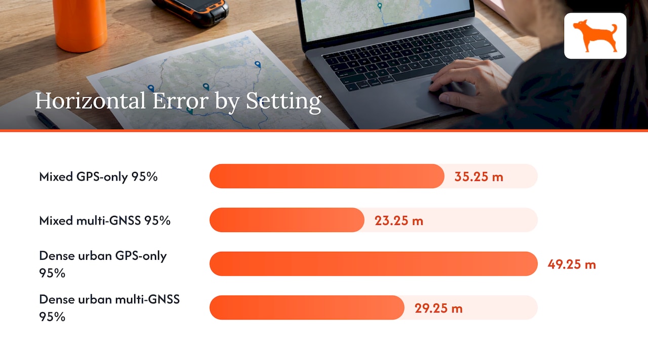
The gap between GPS-only and multi-GNSS shows up when the sky is not open. A GPS.gov advisory presentation from 2015 reported these 95% horizontal accuracy figures:
| Environment | GPS only | Multi-GNSS |
|---|---|---|
| Mixed environments | 35.25 m | 23.25 m |
| Dense urban | 49.25 m | 29.25 m |
The 95% figure means 95 readings out of 100 fell within that distance. It is a worst-case view, not a typical one, which is the right way to think about a fleet: you care about the bad readings as much as the average.
A 2016 study from the Finnish Geospatial Research Institute, published in Annals of Telecommunications, measured open-sky horizontal median error of about 3 m for GPS alone. Any two-system combination came in at 1.8 to 2.8 m, and GPS plus Galileo plus BeiDou reached 1.4 m. In severe urban canyons, the study found GPS-only error could be more than ten times larger, and a GPS-only receiver produced a position fix less than half as often as a multi-GNSS solution.
A 2017 Dutch study in GPS Solutions tested a motorway with a tall noise barrier beside it. Combining GPS and GLONASS kept lane-level accuracy 83.7% of the time, while GPS-only performance broke down as sky visibility dropped.
These are research-grade receivers and test conditions, so treat the numbers as direction rather than a promise for any particular tracker. The direction is consistent: more constellations help most where the view of the sky is poor.
Urban canyons and job sites: where it matters for fleets
An “urban canyon” is a street lined with tall buildings. Signals bounce off the glass and concrete, arrive late, and push the calculated position off. Your vehicle can appear to be on the next block or in the wrong lane.
Heavy equipment faces its own version of this. A machine working at the base of a cut, beside a stockpile, or under a tree line sees only part of the sky. Equipment parked in a tight rental yard, nose to tail with other machines, has the same issue. Septentrio, a GNSS receiver maker, notes that on worksites the sky view is often blocked by machinery, buildings, rocks or foliage, which is why tracking more signals from more systems helps keep a position.
For most fleet decisions, though, you are not surveying. You need to know:
- Which yard, site or road a unit is on.
- Whether it crossed a boundary you set.
- Whether it moved when it should not have.
- How many miles and idle hours it logged.
Meter-level or even tens-of-meters error rarely changes those answers. A geofence around a job site is usually drawn with a margin larger than that. What does change them is a tracker that loses its position entirely, or cannot report it.
The part people overlook: reporting the position
A GNSS chip tells the device where it is. A cellular modem tells you. If the modem cannot connect, the best satellite fix in the world sits on the device and never reaches your dashboard.
The GSMA’s February 2025 asset-tracking guide describes integrated trackers that switch between Bluetooth, Wi-Fi, LTE-M, NB-IoT and satellite links, and lists construction and heavy-equipment management as a key use case for monitoring usage, location and maintenance. It also notes that satellite links draw more power and cost more than terrestrial ones, so devices reduce how often they report to conserve battery.
That battery point is a real fleet constraint. A trailer or piece of equipment with no vehicle power relies on the tracker’s own battery. Reporting more often gives a fresher picture but drains it faster. When you evaluate any tracker, look at battery life together with the reporting interval you will actually use.
For a deeper look at how tracking hardware and networks fit together, see our overview of what uses GPS tracking to track vehicles.
Bluetooth tags vs GPS trackers
People often ask whether a Bluetooth tag can do the job of a GPS tracker. They are different tools.
A Bluetooth tag has no satellite receiver at all. EDN’s teardown of a popular Bluetooth tracker found no power-hungry GPS hardware inside. Within about 200 feet of a paired phone, the phone records the tag’s approximate location. Out of range, the app shows the last known spot, and other phones in the same network may anonymously report a sighting.
The Bluetooth SIG lists low power, low cost and large-scale deployment as the strengths of Bluetooth Low Energy in asset tracking. It also notes medium accuracy in signal-strength-based systems, and describes facility deployments where fixed locators estimate a beacon’s position.
For a rental fleet, that translates as follows:
- Bluetooth tags suit small tools and items inside a yard or warehouse where fixed readers or phones are always nearby.
- A cellular GPS tracker suits anything that drives, is hauled or is delivered to a customer site, because it reports its own position wherever there is coverage, with no phone or reader nearby.
A skid steer on a lowboy halfway across the state is exactly the case where nearby-phone detection gives you nothing, and a cellular tracker gives you a live position.
What to look for in a fleet tracker
Use this checklist for any tracker you consider, whatever the satellite system behind it:
- Real-time location on a map you can open from a phone or desk.
- Geofencing and alerts for yard exits, after-hours movement and site arrivals.
- Trip and mileage reports that save you from rebuilding logs by hand.
- Idle time tracking, which shows fuel burned for no work.
- Maintenance reminders tied to hours or mileage, so service is scheduled rather than discovered. If you track service by standard codes, our explainer on VMRS code meaning shows how they organize repair records.
- Battery life long enough for unpowered trailers and attachments.
- Total cost over the life of the unit. Hardware price plus data plan, activation fees and add-ons, over the years you will hold the asset.
That last item is where fleets most often get surprised. A low sticker price with a monthly fee per unit adds up fast across dozens of machines. Multiply the monthly fee by the number of units and the years of service, then compare it with a one-time purchase.
A worked example: 25 units over three years
Suppose you rent out 25 pieces of equipment and want every one tracked. At a hypothetical $15 per unit per month, a subscription plan costs $375 a month, or $13,500 over 36 months, before any hardware cost. That $15 is an illustration, not a quote from any provider.
With a one-time purchase starting at $124.99 per device, 25 units at that starting price come to $3,124.75 once, and no recurring data charge follows. Your actual cost depends on the model you choose, but the structure is the point: the cost is known the day you buy, and it does not grow as the fleet ages or expands.
Perspective
We think the GPS-versus-GNSS debate gets more attention than it deserves for fleet work, and the network and cost questions get less. Satellites are free and shared. What differs between trackers is what happens after the position is calculated: does it reach your dashboard, how often, and what do you pay for it every month?
Our approach is to include lifetime 4G data with the device, with no monthly or recurring fees, no activation fees and no add-ons. You get real-time tracking, geofencing alerts, trip and mileage reports, idle time tracking and maintenance reminders in one dashboard, with unlimited vehicles and users on that account. Fleet managers and equipment renters should not have to budget a subscription line for every unit they own.
More than 1,000 businesses rely on our trackers for accuracy. When you track a 25-unit fleet, that structure is what makes the math simple: you pay once per device, then you manage the whole fleet from one place.
Louis
Our trackers for fleets and equipment
Moto Watchdog trackers cover vehicles, trailers, heavy equipment and personal assets, with real-time location, customizable geofencing and alerts, long battery life, trip and mileage reporting, and push notifications. A free companion app lets you manage multiple devices, share access and set maintenance reminders. Same-day replies on sales and support come with no sales sequence.
Pricing starts at $124.99 as a one-time purchase, with lifetime 4G data included. Larger operations can use API access to bring location data into their own systems; see the business page for details.
See the full lineup on our tracker page and pick the model that fits your fleet.
FAQ
Does my phone use GPS or GNSS?
Most modern smartphones use GNSS. That means GPS plus other constellations where the chip supports them, even though the setting is usually labeled “GPS” or “location.” The device blends the satellites it can hear. Under open sky, GPS.gov says typical phone accuracy is within about 4.9 m (16 ft).
Is GNSS more accurate than GPS?
It can be, mainly in places with a blocked view of the sky. Government and university measurements show lower error and better availability for multi-constellation positioning in dense urban settings. Under open sky, GPS alone is already accurate enough for most fleet reporting.
Do I need to choose between GLONASS, Galileo and GPS?
No. The systems coordinate their signal frequencies, so one receiver and one antenna can listen to several of them. For fleet owners, the choice that counts is the tracker’s reporting, battery and cost, not which constellation name appears on the box.
Can a Bluetooth tag replace a GPS tracker on equipment?
Not for equipment that leaves your yard. A Bluetooth tag relies on a nearby phone or reader to report its location, with a range of roughly 200 feet to a paired phone. A cellular GPS tracker reports on its own, anywhere it has coverage.
What is an urban canyon?
It is a street where tall buildings block much of the sky and reflect satellite signals. Reflected signals arrive late and can shift the calculated position by tens of meters. Having more satellites available, from several constellations, is the usual way to reduce the effect.
Sources
- Other Global Navigation Satellite Systems (GNSS), GPS.gov
- GPS Accuracy, GPS.gov
- Benefits of Using Multi-GNSS for Mobile/Cellular, GPS.gov advisory, 2015
- GNSS vs. GPS, EarthScope Consortium
- The future of GPS, Stanford University School of Engineering
- A multi-GNSS software-defined receiver, Annals of Telecommunications, 2016
- Real-time multi-GNSS single-frequency precise point positioning, GPS Solutions, 2017
- Why do you need a multi-frequency multi-constellation GPS receiver, Septentrio
- Smart Logistics: Designing Integrated 5G and Satellite Asset Tracking, GSMA, 2025
- Teardown: Tile Mate Bluetooth tracker relies on software, EDN, 2021
- Wireless connectivity options for IoT applications: asset tracking, Bluetooth SIG, 2020