
How to start saving money
Lorem ipsum dolor sit amet, consectetur adipiscing elit lobortis arcu enim urna adipiscing praesent velit viverra sit semper lorem eu cursus vel hendrerit elementum morbi curabitur etiam nibh justo, lorem aliquet donec sed sit mi dignissim at ante massa mattis.
- Neque sodales ut etiam sit amet nisl purus non tellus orci ac auctor
- Adipiscing elit ut aliquam purus sit amet viverra suspendisse potent
- Mauris commodo quis imperdiet massa tincidunt nunc pulvinar
- Excepteur sint occaecat cupidatat non proident sunt in culpa qui officia
Why it is important to start saving
Vitae congue eu consequat ac felis placerat vestibulum lectus mauris ultrices cursus sit amet dictum sit amet justo donec enim diam porttitor lacus luctus accumsan tortor posuere praesent tristique magna sit amet purus gravida quis blandit turpis.

How much money should I save?
At risus viverra adipiscing at in tellus integer feugiat nisl pretium fusce id velit ut tortor sagittis orci a scelerisque purus semper eget at lectus urna duis convallis. porta nibh venenatis cras sed felis eget neque laoreet suspendisse interdum consectetur libero id faucibus nisl donec pretium vulputate sapien nec sagittis aliquam nunc lobortis mattis aliquam faucibus purus in.
- Neque sodales ut etiam sit amet nisl purus non tellus orci ac auctor
- Adipiscing elit ut aliquam purus sit amet viverra suspendisse potenti
- Mauris commodo quis imperdiet massa tincidunt nunc pulvinar
- Adipiscing elit ut aliquam purus sit amet viverra suspendisse potenti
What percentege of my income should go to savings?
Nisi quis eleifend quam adipiscing vitae aliquet bibendum enim facilisis gravida neque. Velit euismod in pellentesque massa placerat volutpat lacus laoreet non curabitur gravida odio aenean sed adipiscing diam donec adipiscing tristique risus. amet est placerat in egestas erat imperdiet sed euismod nisi.
“Nisi quis eleifend quam adipiscing vitae aliquet bibendum enim facilisis gravida neque velit euismod in pellentesque”
Do you have any comments? Share them with us on social media
Eget lorem dolor sed viverra ipsum nunc aliquet bibendum felis donec et odio pellentesque diam volutpat commodo sed egestas aliquam sem fringilla ut morbi tincidunt augue interdum velit euismod eu tincidunt tortor aliquam nulla facilisi aenean sed adipiscing diam donec adipiscing ut lectus arcu bibendum at varius vel pharetra nibh venenatis cras sed felis eget.
Fleet GPS data integration is the process of connecting real-time vehicle location data with fleet management systems, telematics platforms, and operational workflows to improve visibility and decision-making. The industry term for this broader practice is telematics integration, and the two terms are used together throughout this article. For fleet managers and IT professionals, the most practical fleet GPS data integration examples involve combining GPS coordinates with diagnostic fault codes, compliance data, and streaming event architectures. Platforms like Geotab, Samsara, and Motive have made this type of integration more accessible, but the technical depth required still catches many teams off guard.
1. Fleet GPS data integration examples: telematics and SAE J1939 fault codes
The most common heavy-duty fleet GPS data integration example connects vehicle diagnostic fault codes with GPS location data. This combination tells you not just that a truck has a fault, but exactly where that fault occurred on a route.

The standard that makes this possible is SAE J1939 SPN/FMI. Every fault message carries two identifiers. The Suspect Parameter Number (SPN) identifies the component affected. The Failure Mode Identifier (FMI) describes how it failed. For example, SPN 4364 FMI 5 points to a specific sensor fault on an emissions system component. That level of specificity is what separates diagnostic-aware GPS integration from basic location tracking.
When you correlate fault events with GPS coordinates, you can answer questions like:
- Which road segments trigger the most engine fault events?
- Are faults clustering near a specific depot or loading zone?
- Does a particular driver’s route produce recurring fault patterns?
- Which fault codes appear most frequently before a vehicle goes offline?
These questions drive predictive maintenance decisions. Instead of waiting for a breakdown, your maintenance team gets a fault code tied to a map location and a timestamp. That context changes the response from reactive repair to scheduled intervention.
Pro Tip: Use the J1939 SPN/FMI code structure as your canonical fault representation across all vehicle makes. This stable abstraction decouples your analytics from proprietary vendor telemetry formats, making it far easier to add new vehicle types later.
2. End-to-end GPS integration with open-source toolkits
Open-source toolkits give fleet IT teams a transparent, customizable starting point for GPS data integration. The freight-eta-toolkit is one of the clearest practical examples of this approach.
The toolkit pulls GPS coordinates from three major fleet platforms: Geotab, Samsara, and Motive. It handles credentials management per platform, applies geofencing math, and logs lifecycle events tied to physical locations. The result is a unified event stream regardless of which GPS fleet management solution your fleet uses.
The integration workflow works in four stages:
- Authenticate against each platform’s API using stored credentials.
- Poll vehicle positions at a configurable interval, typically every 60–120 seconds.
- Evaluate each position against defined geofence boundaries using coordinate math.
- Log lifecycle events such as “arrived at pickup,” “departed pickup,” and “arrived at drop.”
This event model maps directly to dispatch and billing workflows. When a driver arrives at a pickup location, the system logs a timestamped event automatically. That event can trigger a notification to the shipper, update an ETA dashboard, or feed into a billing system.
The freight-eta-toolkit also demonstrates how to handle the geofencing logic itself. Zone entry and exit detection runs on every polling cycle, and the toolkit applies hysteresis to prevent false positives from GPS drift near zone boundaries.
Pro Tip: When building your own integration on top of a toolkit like this, log raw GPS coordinates separately from processed lifecycle events. Raw logs let you replay and reprocess events if your geofence boundaries change.
3. Real-time streaming architectures for GPS and telematics data
Real-time fleet tracking requires more than polling an API every few minutes. High-frequency telematics data, including speed, engine RPM, and harsh braking events, demands a streaming architecture that processes events as they arrive.
The most practical approach uses Apache Kafka for event ingestion combined with SQL-based stream processing. Kafka acts as the message bus, receiving telematics events from vehicles and making them available to downstream consumers. SQL stream processing then applies transformations, aggregations, and alerting logic without requiring custom code for every use case.
The table below shows the key data structures in a streaming telematics architecture:
| Data Structure | Description | Update Frequency |
|---|---|---|
| Raw event stream | Incoming GPS and engine data per vehicle | Continuous |
| vehicle_current_position | Materialized view of latest known position | On each new event |
| Performance summary | Aggregated speed, RPM, braking over time windows | Every 15 minutes |
| Alert triggers | Threshold-based outputs for speed or fault events | Real-time |
The materialized view for vehicle_current_position is the most operationally useful output. It gives dispatchers a live map without querying the full event history on every refresh. Materialized views separate the raw event store from the live position cache, which keeps query performance fast even as event volume grows.
SQL-based stream processing also removes the need for custom stream processing code. Fleet IT teams can write standard SQL queries to define aggregations, joins, and alert conditions. That lowers the skill barrier significantly compared to writing custom Kafka consumer applications.
4. Geofencing event accuracy: hysteresis and sampling cadence
Geofencing is one of the most widely used GPS data analysis techniques in fleet management, but poor implementation produces noisy, unreliable events. The two technical factors that determine geofencing accuracy are sampling cadence and hysteresis.
Sampling cadence is how often the system checks a vehicle’s position against geofence boundaries. The freight-eta-toolkit uses a polling interval of 60–120 seconds. That cadence balances API rate limits against event timeliness. Polling too infrequently misses short stops. Polling too frequently exhausts API quotas and increases processing load.
Hysteresis prevents false positive events caused by GPS drift. Without hysteresis, a vehicle parked near a geofence boundary can trigger repeated entry and exit events as its reported position fluctuates by a few meters. Hysteresis requires the system to observe a consistent position transition over multiple polling cycles before logging a state change. This technique is standard in well-built geofence event logic and should be a requirement in any integration you build or evaluate.
For fleet managers reviewing fleet tracking software examples, ask vendors directly whether their geofencing implementation uses hysteresis. If they cannot answer that question, the system likely produces noisy event data.
5. Integrating GPS fleet data with ELD and HOS compliance systems
Hours of Service (HOS) compliance is a legal requirement for commercial fleets, and GPS data integration with Electronic Logging Device (ELD) systems is one of the highest-value examples of fleet data management available.
The Motive ELD API SDK exposes structured endpoints that connect GPS location data with driver duty status. Key data types available through this integration include:
- Locations: Current and historical GPS coordinates tied to driver sessions.
- Geofences: Defined zones that trigger compliance-relevant events.
- HOS logs: Duty status records correlated with trip data.
- hosViolations: Flagged records where driving time exceeded legal limits.
When GPS trip data and HOS logs share a common driver and timestamp, dispatch teams can see whether a driver approaching a delivery location has hours remaining to complete the trip. That correlation prevents HOS violations before they happen rather than discovering them in a post-trip audit.
The Motive ELD API SDK provides methods for querying all of these data types programmatically. Fleet IT teams can build internal dashboards that surface compliance risk in real time, without relying on the vendor’s own interface. This approach also supports GPS fleet safety improvements by giving managers visibility into both location and legal duty status simultaneously.
6. Multi-vendor data normalization for fleet GPS systems
Most fleets run vehicles from multiple manufacturers and use more than one telematics platform. That creates a data normalization problem. Each vendor delivers GPS and telematics data in a proprietary schema, and building analytics on top of multiple schemas is expensive to maintain.
The solution is a canonical event stream. A normalization layer reads raw data from each vendor’s API and transforms it into a single, consistent schema before it reaches your analytics or alerting systems. This approach is sometimes called event stream canonicalization, and it is the foundation of any scalable multi-vendor GPS fleet management solution.
Fleet IT integration projects frequently overlook protocol translation complexity. A truck from one manufacturer may report engine RPM in a different field name, unit, or update frequency than a truck from another. Without normalization, every downstream system must handle these differences individually. A canonical event stream solves this once, centrally, and every consumer benefits.
For teams evaluating types of fleet GPS systems, prioritize platforms that expose a documented, stable API schema. Proprietary formats that change without notice are the single biggest source of integration maintenance cost.
7. Benefits of GPS integration across fleet operations
GPS integration delivers measurable operational benefits when implemented correctly. Effective GPS integration connects location data with dispatch, maintenance, and driver compliance systems to produce a unified operational picture.
The core benefits break down by function:
- Dispatch: Real-time vehicle positions reduce check-in calls and improve load assignment accuracy.
- Maintenance: Fault codes correlated with GPS location enable predictive scheduling instead of reactive repair.
- Compliance: HOS and ELD integration surfaces violations before they become regulatory penalties.
- Cost control: Accurate mileage data from GPS feeds directly into fuel reporting and reimbursement workflows.
For small and mid-size fleets, the cost barrier to GPS integration has dropped significantly. Budget-conscious fleet tracking options now include subscription-free hardware that still supports API-level data access. That means even a 10-vehicle contractor fleet can implement the same integration patterns used by enterprise logistics operators.
Key takeaways
Fleet GPS data integration delivers the most value when GPS location data is combined with diagnostic fault codes, HOS compliance records, and real-time streaming architectures rather than treated as a standalone data source.
| Point | Details |
|---|---|
| Use SAE J1939 as your fault standard | SPN/FMI codes create a vendor-neutral fault representation that simplifies multi-platform analytics. |
| Apply hysteresis in geofencing | Consistent position transitions over multiple polling cycles prevent false entry and exit events. |
| Separate position views from raw events | Materialized views for current position keep dashboards fast without querying full event history. |
| Normalize data before analytics | A canonical event stream removes per-vendor schema differences from every downstream system. |
| Combine GPS with HOS data | Correlating location and duty status prevents compliance violations before trips are completed. |
What I’ve learned from real fleet GPS integration projects
The gap between a working GPS integration demo and a production-ready system is almost always in the details that nobody documents. Protocol translation is the most underestimated challenge I see. Teams assume that because two platforms both output “latitude” and “longitude,” the rest of the data will align. It rarely does. Engine RPM units, timestamp formats, and event naming conventions vary enough across Geotab, Samsara, and Motive to break downstream analytics in ways that take days to diagnose.
The second lesson is about geofencing. Most teams set a polling interval and forget about hysteresis entirely. The result is an event log full of phantom arrivals and departures that erodes trust in the system within weeks. Getting the sampling cadence right, typically 60–120 seconds, and adding hysteresis logic is not optional. It is the difference between a system your dispatchers trust and one they ignore.
My practical recommendation: start with a single integration pattern, either fault-to-GPS correlation or HOS-to-GPS correlation, and get it right before expanding. Open-source toolkits like freight-eta-toolkit give you a working foundation with transparent geofencing logic you can inspect and modify. That transparency is worth more than any proprietary vendor promise. Build on what you can read and test.
— Louis
See how Motowatchdog supports your GPS integration needs
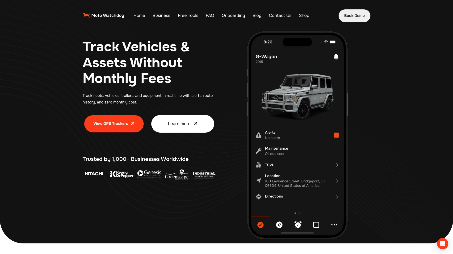
Fleet GPS integration starts with reliable hardware that delivers consistent, accurate location data. Motowatchdog provides subscription-free 4G GPS tracking built for fleet managers who need real-time location data without ongoing monthly fees. Over 1,000 businesses rely on Motowatchdog for accurate vehicle monitoring, customizable geofencing alerts, and detailed mileage reporting that feeds directly into fleet management workflows.
Whether you are building a Kafka-based streaming architecture or connecting GPS data to an ELD compliance system, Motowatchdog gives you the hardware foundation to make it work. The hardwired GPS tracker guide covers installation options for permanent fleet deployments. Explore subscription-free tracking at Motowatchdog and remove the recurring cost from your integration budget.
FAQ
What is fleet GPS data integration?
Fleet GPS data integration is the process of connecting real-time vehicle location data with fleet management systems, telematics platforms, diagnostic tools, and compliance software. The goal is a unified operational view that supports dispatch, maintenance, and regulatory compliance.
Which platforms support fleet GPS data integration?
Geotab, Samsara, and Motive are the three most widely used platforms for GPS fleet management solutions. All three expose documented APIs that support location queries, geofencing, and integration with ELD and HOS compliance systems.
How does SAE J1939 improve GPS data integration?
SAE J1939 SPN/FMI codes provide a vendor-neutral fault standard that maps diagnostic events to GPS locations. This makes it possible to correlate fault data across multiple vehicle makes without building separate parsers for each manufacturer.
What is the best polling interval for geofencing?
A polling interval of 60–120 seconds balances API rate limits against event timeliness for most fleet operations. Pairing that cadence with hysteresis logic prevents false positive zone entry and exit events caused by GPS drift.
How does GPS integration support HOS compliance?
GPS trip data combined with ELD duty status records lets dispatch teams see whether a driver has hours remaining before assigning a new load. The Motive ELD API SDK exposes HOS logs and violation records that can be queried programmatically for real-time compliance monitoring.