How to start saving money
Lorem ipsum dolor sit amet, consectetur adipiscing elit lobortis arcu enim urna adipiscing praesent velit viverra sit semper lorem eu cursus vel hendrerit elementum morbi curabitur etiam nibh justo, lorem aliquet donec sed sit mi dignissim at ante massa mattis.
- Neque sodales ut etiam sit amet nisl purus non tellus orci ac auctor
- Adipiscing elit ut aliquam purus sit amet viverra suspendisse potent
- Mauris commodo quis imperdiet massa tincidunt nunc pulvinar
- Excepteur sint occaecat cupidatat non proident sunt in culpa qui officia
Why it is important to start saving
Vitae congue eu consequat ac felis placerat vestibulum lectus mauris ultrices cursus sit amet dictum sit amet justo donec enim diam porttitor lacus luctus accumsan tortor posuere praesent tristique magna sit amet purus gravida quis blandit turpis.

How much money should I save?
At risus viverra adipiscing at in tellus integer feugiat nisl pretium fusce id velit ut tortor sagittis orci a scelerisque purus semper eget at lectus urna duis convallis. porta nibh venenatis cras sed felis eget neque laoreet suspendisse interdum consectetur libero id faucibus nisl donec pretium vulputate sapien nec sagittis aliquam nunc lobortis mattis aliquam faucibus purus in.
- Neque sodales ut etiam sit amet nisl purus non tellus orci ac auctor
- Adipiscing elit ut aliquam purus sit amet viverra suspendisse potenti
- Mauris commodo quis imperdiet massa tincidunt nunc pulvinar
- Adipiscing elit ut aliquam purus sit amet viverra suspendisse potenti
What percentege of my income should go to savings?
Nisi quis eleifend quam adipiscing vitae aliquet bibendum enim facilisis gravida neque. Velit euismod in pellentesque massa placerat volutpat lacus laoreet non curabitur gravida odio aenean sed adipiscing diam donec adipiscing tristique risus. amet est placerat in egestas erat imperdiet sed euismod nisi.
“Nisi quis eleifend quam adipiscing vitae aliquet bibendum enim facilisis gravida neque velit euismod in pellentesque”
Do you have any comments? Share them with us on social media
Eget lorem dolor sed viverra ipsum nunc aliquet bibendum felis donec et odio pellentesque diam volutpat commodo sed egestas aliquam sem fringilla ut morbi tincidunt augue interdum velit euismod eu tincidunt tortor aliquam nulla facilisi aenean sed adipiscing diam donec adipiscing ut lectus arcu bibendum at varius vel pharetra nibh venenatis cras sed felis eget.
GPS tracking fits mobile, wide-area assets like vehicles, trailers, and equipment that move across long distances. RFID fits proximity and identity tracking, confirming what an item is the moment it passes a checkpoint, gate, or dock door. Many operations need both: GPS for continuous location, RFID for verified identity at fixed points. The sections below walk through the technical differences, a side-by-side comparison, and a decision checklist to help you choose.
TL;DR:
- RFID provides instant identity verification at fixed points over a limited range, requiring infrastructure and often featuring low per-tag costs.
- GPS offers continuous outdoor tracking with accuracy to a few meters, but consumes more power and performs poorly indoors or in dense structures.
- Combining RFID and GPS enables precise chain-of-custody tracking, with RFID confirming identity and GPS monitoring location during transit.
- Choosing the right technology depends on whether the priority is fixed checkpoint verification or wide-area, continuous location monitoring.
- Pilot testing in real operational environments is essential to avoid costly mistakes and ensure alignment with specific asset management needs.
Table of Contents
- How RFID and GPS work and why their mechanics matter to buyers
- Side-by-side comparison: range, power, and where each technology fits
- Benefits and downsides: practical operational impacts of choosing RFID or GPS
- Implementation considerations: how to budget and plan for RFID or GPS deployment
- Hybrid use cases and integration patterns
- Decision checklist: 6 questions to choose RFID, GPS, or both
- Where subscription-free GPS devices fit the decision process
- What this comparison gets wrong in most buying guides
- Consider subscription-free GPS tracking for mobile assets
- Sources
- FAQ
How RFID and GPS work and why their mechanics matter to buyers
RFID relies on a tag and a reader. Passive tags carry no battery and only respond when a reader’s radio signal powers them, which keeps costs low but limits range. Active tags carry their own power source and broadcast continuously, extending range at a higher per-unit cost. Most commercial passive tags follow the EPC Gen2 standard, which governs how readers and tags communicate and matters if you’re buying from multiple vendors and need interoperability, according to DHS.
GPS tracking works differently. A device with a GNSS chip calculates its position using satellite signals, described in the FAA’s GPS overview. From there, the device either logs that position for later download (passive logging) or transmits it in near real time over a cellular or satellite network (active tracking). This distinction matters more than most buyers realize.
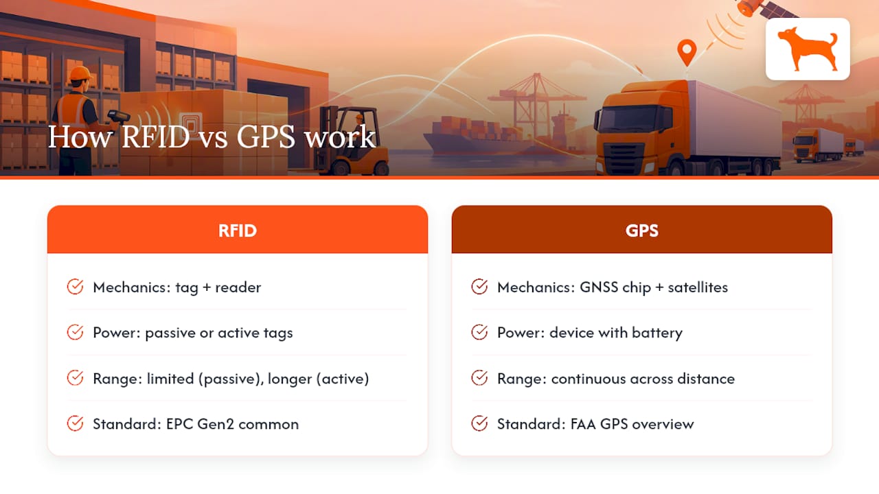
Marketing language often blurs the line. A product labeled “GPS-enabled” might only log coordinates for a technician to retrieve after the fact, not send live updates you can view on a dashboard. Before buying, confirm whether the device actively transmits and what network it uses. DHS’s technical guidance on asset tracking systems treats RFID as detection at a point and GPS as continuous tracking across distance, a distinction worth holding onto through every purchasing decision.
Side-by-side comparison: range, power, and where each technology fits
| Attribute | RFID | GPS |
|---|---|---|
| Detection range/accuracy | Passive: several meters; active: 100+ meters (GS1) | Continuous positioning, accurate to a few meters outdoors |
| Real-time capability | Instant at point of contact, not continuous | Continuous updates on active devices |
| Indoor/outdoor performance | Strong indoors; range limited by materials | Strong outdoors; degraded or unreliable indoors |
| Power/battery | Passive tags need none; active tags need periodic replacement | Requires charging or hardwiring, ongoing power draw |
| Infrastructure | Readers, gateways, middleware | Cellular or satellite network, backend software |
| Data type | Identity (what the item is) | Geo-coordinates (where the item is) |
| Typical cost shape | Low per-tag cost, higher reader infrastructure cost | Higher per-device cost, potential network fees |
A few edge cases are worth flagging. UHF passive tags read only a few meters under normal conditions, and that range depends heavily on antenna design, polarization, and how the tag is mounted, not just the tag’s rated specification, per GS1.
- Active RFID tags have longer range than passive ones but require battery upkeep and higher cost per unit.
- GPS accuracy drops indoors or in dense structures, while RFID checkpoints often maintain better performance.
Benefits and downsides: practical operational impacts of choosing RFID or GPS
RFID’s biggest strength is speed at scale. A reader can identify dozens of tagged items in seconds without needing a direct line of sight, which makes it efficient for inventory counts and dock verification. Passive tags cost little per unit, so tagging large numbers of items is financially realistic. The trade-off is infrastructure: readers, gateways, and middleware require upfront investment, and passive tags only work within a limited range. Active tags extend that range but introduce battery replacement schedules and, per FHWA’s evaluation of identification methods, security considerations since geolocation-enabled active RFID exposes location data that needs to be secured.
GPS delivers continuous, wide-area visibility. Geofencing alerts, trip logs, and mileage reports work because the device knows where it is at all times, not just when it passes a checkpoint. The downsides are power management, since active transmission drains batteries faster than passive logging, and weaker indoor performance. Some GPS products also carry recurring data or subscription fees, a cost structure worth comparing against subscription-free device models before committing.
- RFID: fast, low-cost per tag, but range-limited and infrastructure-heavy.
- GPS: continuous location and reporting, but power-hungry and weaker indoors.
Security planning differs by technology. RFID backends need access controls governing who can query tag data, while GPS deployments in reliability-critical settings should account for potential GNSS interference risks raised in federal analysis of L-band operations.
Pro Tip: Match the technology to the job first: identity confirmation points toward RFID, continuous location points toward GPS.
Implementation considerations: how to budget and plan for RFID or GPS deployment
Deployment planning looks different for each technology, and skipping steps here is where most projects overrun budget.
- RFID: choose passive or active tags, count and position readers or gateways, decide on tag mounting methods, and test middleware integration before full rollout.
- GPS: decide between hardwired or battery-powered mounting, choose a cellular or satellite network, set update intervals, and plan data export and API needs.
- Budget shape: RFID costs scale with tag count plus reader infrastructure, while GPS costs scale with per-device hardware and, in some models, recurring network fees.
Run a pilot before scaling either system. Testing in your actual environment surfaces read-rate problems, battery drain, or coverage gaps that specification sheets never mention.
Hybrid use cases and integration patterns
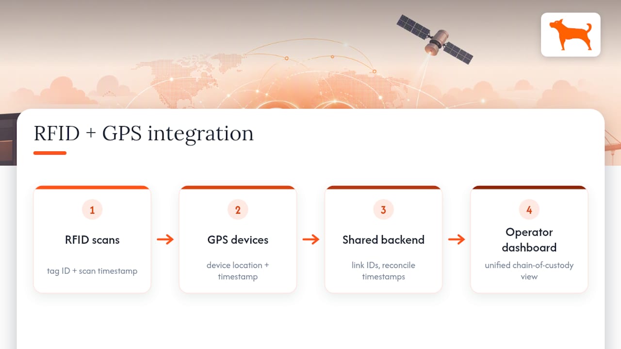
Fleet and yard operations often benefit from combining both technologies. GPS tracks a vehicle or trailer’s location across a route, while RFID readers at gates and dock doors confirm exactly what load is present at each stop, creating a chain-of-custody record GPS alone can’t provide.
Inventory and transit workflows follow a similar pattern. RFID scans serialized items as they’re staged for shipment, and GPS provides visibility once those items are in transit. Federal case studies on underground asset management describe this same principle: GNSS locates, RFID confirms identity, and the two together eliminate blind spots that either system leaves on its own.
Integrating them means linking tag IDs to device location records in a shared backend, reconciling timestamps between the two data streams, and designing a dashboard operators can read without needing to interpret raw feeds.
Decision checklist: 6 questions to choose RFID, GPS, or both
Work through these before briefing any vendor.
- Do you need to confirm identity or track location? Identity points to RFID, location points to GPS.
- Is the asset mobile across wide areas, or fixed near checkpoints? Mobile favors GPS, fixed favors RFID.
- Do you need indoor or outdoor coverage? RFID often performs better indoors, GPS outdoors.
- What update frequency do you actually need? Continuous tracking requires active GPS transmission, not passive logging.
- What’s your infrastructure budget? RFID needs readers and gateways, GPS needs devices and network access.
- Do you need both? Combine them when identity and continuous location both matter.
Watch for vendor red flags: unclear update intervals, no API access, or data locked to a proprietary dashboard.
Pro Tip: Pilot your shortlist for 30 to 90 days in a real workflow before committing to a full rollout.
Where subscription-free GPS devices fit the decision process
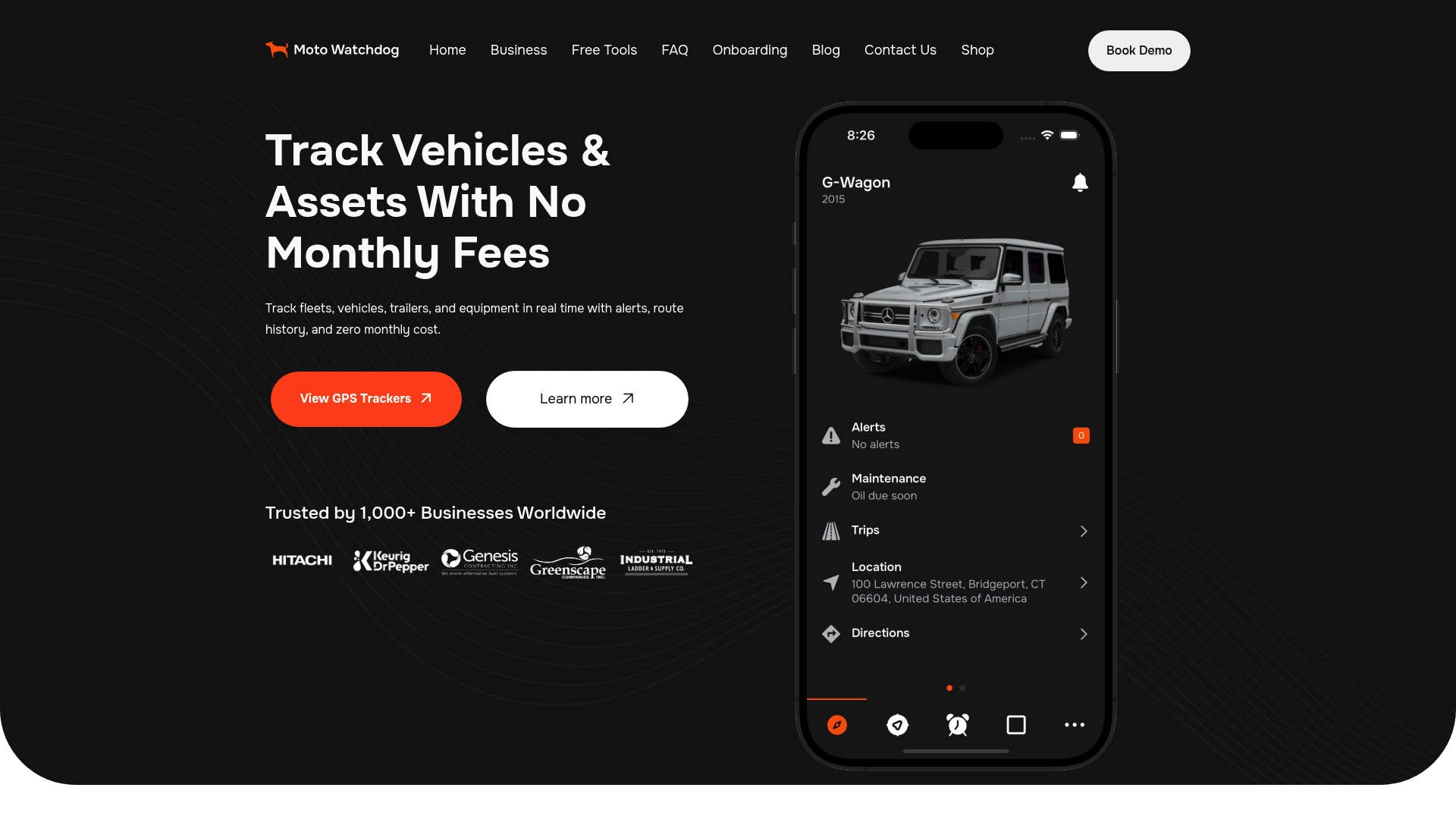
For buyers who land on GPS as the right fit, Moto Watchdog offers subscription-free GPS trackers with real-time location, customizable geofencing, long battery life, and mileage reporting built for fleet and personal asset use. This covers vehicle and fleet tracking, geofence alerts on job sites, and trip logs without recurring fees.
It does not replace RFID where identity confirmation at a checkpoint, dock, or gate is the actual requirement. Read more about how subscription-free GPS trackers work before deciding.
What this comparison gets wrong in most buying guides
Most comparisons frame RFID and GPS as competitors, as if choosing one settles the question. That framing misses how differently the two technologies fail. GPS quietly loses accuracy indoors or during signal interference, while RFID quietly fails when a tag is misaligned with a reader’s antenna. Neither weakness shows up on a spec sheet, only in a real deployment.
The bigger mistake is buying based on range or update-frequency numbers alone, without first asking whether the job is identity confirmation or continuous location. A checkpoint problem solved with GPS wastes money on hardware that was never suited to the task, and a mobile-tracking problem solved with RFID leaves blind spots between checkpoints. Readers evaluating either technology should start with the job, not the spec sheet, and treat a short pilot as mandatory rather than optional. That single step catches more expensive mistakes than any comparison table ever will.
— Louis
Consider subscription-free GPS tracking for mobile assets
If your checklist points to GPS, Real-time tracking with no monthly fees, geofencing alerts, and mileage reporting built for fleets and personal vehicles is available.
- No recurring subscription cost on tracking hardware.
- Geofencing and mileage reports built into the device.
Browse Moto Watchdog’s GPS trackers to see current models and pricing.
Sources
- Asset Tracking and Inventory Systems technical note
- Chapter 5. Evaluation of ID Methods | FHWA
- Impact of L-band MSS direct-to-device operations on GPS — Federal Register
FAQ
Can you track people with RFID?
RFID can identify a person carrying a tagged badge or wristband as they pass a reader, but it only detects proximity at that checkpoint, not continuous movement. For ongoing location tracking of a person, GPS is the more suitable technology.
Is an AirTag an RFID?
No. An AirTag primarily uses Bluetooth and crowdsourced location networks rather than RFID’s reader-and-tag system. It works differently from both RAIN RFID tags and GPS devices, relying on nearby devices to relay its location.
What are the downsides of RFID technology?
Passive RFID has a limited read range, generally up to several meters, and requires reader infrastructure at checkpoints, according to GS1. Active tags extend range but need battery upkeep and, per FHWA, enhanced security design to protect location data.
How far can RFID be tracked?
Read range depends on tag class: passive UHF tags typically read several meters, while active tags can reach 100 meters or more, according to GS1. Actual range in the field also depends on antenna design, tag orientation, and installation conditions.