How to start saving money
Lorem ipsum dolor sit amet, consectetur adipiscing elit lobortis arcu enim urna adipiscing praesent velit viverra sit semper lorem eu cursus vel hendrerit elementum morbi curabitur etiam nibh justo, lorem aliquet donec sed sit mi dignissim at ante massa mattis.
- Neque sodales ut etiam sit amet nisl purus non tellus orci ac auctor
- Adipiscing elit ut aliquam purus sit amet viverra suspendisse potent
- Mauris commodo quis imperdiet massa tincidunt nunc pulvinar
- Excepteur sint occaecat cupidatat non proident sunt in culpa qui officia
Why it is important to start saving
Vitae congue eu consequat ac felis placerat vestibulum lectus mauris ultrices cursus sit amet dictum sit amet justo donec enim diam porttitor lacus luctus accumsan tortor posuere praesent tristique magna sit amet purus gravida quis blandit turpis.

How much money should I save?
At risus viverra adipiscing at in tellus integer feugiat nisl pretium fusce id velit ut tortor sagittis orci a scelerisque purus semper eget at lectus urna duis convallis. porta nibh venenatis cras sed felis eget neque laoreet suspendisse interdum consectetur libero id faucibus nisl donec pretium vulputate sapien nec sagittis aliquam nunc lobortis mattis aliquam faucibus purus in.
- Neque sodales ut etiam sit amet nisl purus non tellus orci ac auctor
- Adipiscing elit ut aliquam purus sit amet viverra suspendisse potenti
- Mauris commodo quis imperdiet massa tincidunt nunc pulvinar
- Adipiscing elit ut aliquam purus sit amet viverra suspendisse potenti
What percentege of my income should go to savings?
Nisi quis eleifend quam adipiscing vitae aliquet bibendum enim facilisis gravida neque. Velit euismod in pellentesque massa placerat volutpat lacus laoreet non curabitur gravida odio aenean sed adipiscing diam donec adipiscing tristique risus. amet est placerat in egestas erat imperdiet sed euismod nisi.
“Nisi quis eleifend quam adipiscing vitae aliquet bibendum enim facilisis gravida neque velit euismod in pellentesque”
Do you have any comments? Share them with us on social media
Eget lorem dolor sed viverra ipsum nunc aliquet bibendum felis donec et odio pellentesque diam volutpat commodo sed egestas aliquam sem fringilla ut morbi tincidunt augue interdum velit euismod eu tincidunt tortor aliquam nulla facilisi aenean sed adipiscing diam donec adipiscing ut lectus arcu bibendum at varius vel pharetra nibh venenatis cras sed felis eget.
For most fleet and equipment geofences, start with a radius of about 150 meters (roughly 500 feet) and adjust from there. Go larger for big yards and open jobsites. Go smaller only where your tracker reports positions precisely and the area around the site is quiet. The right number depends on three things: how accurate your device’s location fix is, how big the site is, and how much alert noise your team will tolerate.
This guide shows how to choose a radius for a yard, a jobsite or a delivery area. It also covers how to set entry and exit alerts, how to test the result, and what to check when alerts are missed or false.
TL;DR
- A radius geofence is a circle around a center point. Change the radius and the circle grows or shrinks. Move the pin and the center moves.
- Android’s developer documentation recommends a minimum radius of 100 to 150 meters for reliable detection. Treat that as a floor, not a target.
- GPS is typically accurate to a few meters in open sky, but buildings, trees and bridges can make it worse. Size the circle with that error in mind.
- Use a polygon, not a circle, when a site has an irregular shape or a neighbor’s property sits right next to it.
- Always test with a real vehicle or machine moving in and out before you rely on the alerts.
Table of Contents
- What a geofence radius actually does
- Why accuracy sets your minimum radius
- Radius sizes by use case
- Circle or polygon?
- How to set a geofence radius step by step
- Testing the radius before you trust it
- What to check when alerts are missed or false
- Using radius geofences for heavy equipment and fleets
- Get a tracker that fits the geofence you plan
- FAQ
- Sources
What a geofence radius actually does
A radius geofence creates a circular boundary around one point, such as an address or a latitude and longitude. TruxNow’s help center describes the same mechanics: changing the radius changes the circle’s size, and moving the map pin moves its center.
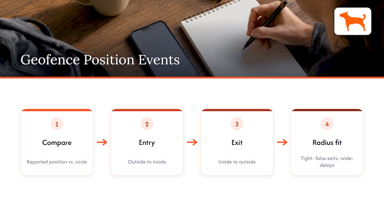
Your tracker reports its position. The platform compares that position with the circle and raises an event when the position moves from outside to inside (entry) or from inside to outside (exit). Everything that follows comes down to one question: how closely does the reported position match where the asset really is?
That is why a radius is never just a drawing choice. It is a tolerance setting. A circle that is too tight turns normal position error into false exits. A circle that is too wide lets an asset travel a long way before anyone hears about it.
Why accuracy sets your minimum radius
GPS accuracy is the starting point for every radius decision. GPS.gov says GPS-enabled smartphones are typically accurate within about 4.9 meters (16 feet) under open sky. It adds that accuracy gets worse near buildings, bridges and trees, and that blocked signals, indoor or underground use and reflected signals (multipath) can all degrade a fix.
A federal transportation research paper reaches a similar figure for GPS data collection: accuracies of three to five meters for second-by-second positions.
Those numbers describe good conditions. A rental yard ringed by steel containers, a jobsite under a highway overpass or a downtown delivery stop is not good conditions. Positions can wander well past the open-sky figure, and a small circle will register that wander as movement.
The practical rule: your radius should be many times larger than the worst error you expect at that location, not just larger than the best-case figure.
What the platform guidance says
Android’s location documentation recommends a minimum geofence radius of 100 to 150 meters. That guidance is written for app developers, but the logic carries over to any location-based alerting. Below that size, detection becomes unreliable because the system cannot confirm a crossing with confidence.
The same page notes that alerts normally arrive in under two minutes, but latency can stretch to about six minutes if the device has been stationary for a long time. A very small circle around a slow-moving machine can therefore produce late alerts even when the setting looks correct.

Radius sizes by use case
The table below gives starting points for common fleet and rental situations. These are our working suggestions for a first setup, built on the minimums above. They are not fixed standards, and you should adjust them after testing.
| Situation | Suggested starting radius | Why |
|---|---|---|
| Large open equipment yard | 200 to 400 m (650 to 1,300 ft) | Assets sit far from the center, and open sky gives a stable fix |
| Contractor jobsite, open ground | 150 to 300 m (500 to 1,000 ft) | Covers laydown areas and staging without catching the road |
| Jobsite in a dense urban block | 150 m or more, or a polygon | Tall buildings degrade the fix, and a tight circle will misfire |
| Customer delivery or pickup location | 150 to 250 m (500 to 800 ft) | Confirms arrival without needing the exact parking spot |
| Home base or shop for a service van | 150 to 200 m (500 to 650 ft) | Logs departures and returns without noise from the lot |
| Wide service territory | Several kilometers | Flags a unit leaving an approved region, not a single site |
Two things to notice. First, nothing in the table drops below the 100 to 150 meter floor. Second, the larger the area you care about, the more forgiving the setting. If you only need to know that a skid steer left the county, a large circle works fine. If you need to know it left a specific fenced lot next to a public road, you need a more careful setup.
Circle or polygon?
A circle is the fastest way to protect a point. It is also the least precise shape. TruxNow notes that a radius suits a general area around a point, while a polygon is more precise for a building, a complex property or boundaries that need exclusions.
Choose a circle when:
- The site is roughly round or square and compact.
- You want a quick, wide net around a yard, shop or delivery stop.
- Your goal is arrival and departure logging, not exact boundary enforcement.
Choose a polygon when:
- The property is long, narrow or L-shaped.
- A public road, a competitor’s lot or a neighbor’s property sits within the circle you would need.
- You want to catch a machine leaving one specific fenced area.
A useful hybrid: set a wide circle as an early-warning perimeter and a tighter shape for the actual boundary. Android’s guidance on real-world scenarios describes a similar layering idea, where a large geofence covers a city-level area and smaller ones are registered inside it as needed.
How to set a geofence radius step by step
The screens differ between platforms, but the workflow is almost always the same.
- Place the center. Enter the address or drop a pin at the middle of the area you want to monitor. For a yard, the center of the parking and storage area is better than the office door.
- Pick a starting radius. Use the table above. If you are unsure, start at 150 meters and widen only if testing shows a need.
- Choose the trigger. Most systems let you alert on entry, exit or both. Equipment leaving a yard after hours usually calls for exit alerts only. Delivery confirmation calls for entry. A rental return calls for both.
- Set a dwell or delay option if available. A dwell setting sends an alert only after the device has stayed inside for a set time. Android describes its dwell transition as a way to cut alert spam, because vehicles that just drive past never trigger it.
- Pick who is notified. Send exit alerts for high-value assets to a dispatcher or the owner. Send routine arrival alerts to a shared inbox or feed so they do not interrupt anyone.
- Save, then test before assigning the geofence to every asset.
Testing the radius before you trust it
A geofence you have not tested is a guess. Run this short check on every new site.
- Put a tracker on a vehicle or machine and note the time.
- Drive it slowly toward the boundary from outside. Record when the entry alert arrives and how far from the edge the vehicle was.
- Leave from the far side of the circle and repeat for exit.
- Park it just inside the boundary for 30 minutes and watch for repeated in and out alerts.
- Repeat at a different time of day. Satellite geometry and traffic both change.
If the alert fires well outside the circle, or late, the radius is too small for the conditions or the update interval is too slow. If alerts fire constantly while the asset sits still, the circle edge is probably running through the place where the asset is parked. Move the center or widen the circle so parking sits comfortably in the middle.
What to check when alerts are missed or false
Most problems trace back to a short list of causes. Work through them in this order.
Radius too small for the location
The most common cause. Dense buildings, tree cover and metal structures push position error well beyond open-sky numbers, as GPS.gov explains. Widen the circle, or switch to a polygon that matches the real site.
Asset parked near the boundary
An asset sitting within a few meters of the edge will drift across it with ordinary position noise and generate repeating entry and exit events. Re-center the geofence so normal parking spots are well inside it.
Location source and update rate
Platforms can evaluate crossings using cell-tower location, GPS coordinates or both, so alert behavior depends on the location source as well as the radius you set. A tracker that reports infrequently to save battery can also cross a boundary and return between two updates without any alert at all. If you need tight boundary detection, check how often your device reports while moving.
Slow alerts on parked equipment
A unit that has been stationary for a long time may report more slowly, and Android’s own figures show latency growing from under two minutes to as long as six in that state. Do not judge a geofence by the first alert after a long idle period.
Too many alerts
If your team has started ignoring notifications, the fix is usually a dwell delay, an exit-only trigger or a larger circle. An alert that nobody reads protects nothing.
Wrong trigger or wrong recipients
Confirm the geofence is set to the event you actually want and that the right people are on the notification list. It sounds basic, and it is the cause more often than you would expect.
Using radius geofences for heavy equipment and fleets
For rental operators and contractors, geofences do three jobs.
- Theft and unauthorized use. An exit alert on a yard or jobsite circle tells you a machine moved when it should not have. Large rental fleets already rely on this. Construction Equipment reported in 2023 that United Rentals had more than 335,000 telematics-equipped units, and that location data combined with geofencing and alerts helps locate equipment quickly, reduce downtime and limit lost or stolen assets.
- Dispatch and billing. Entry and exit times at a customer site give you objective records of when equipment arrived and left.
- Site boundaries. A jobsite fence keeps machines inside the approved work area, and a wider perimeter flags a unit headed toward the road.
For trailers, generators and attachments that do not have a vehicle’s power supply, battery life matters as much as the radius. A device that reports often enough to catch a crossing but still runs for a long time is what makes a small-looking setting like this work in practice. Our guides on GPS tracking devices for equipment and tracking fleet vehicles go deeper on each side.
Our view on geofence radius settings
We see the same pattern again and again: a geofence only works as well as the tracker behind it. A well-chosen radius cannot fix a device that reports rarely, drops offline or comes with a monthly bill that tempts people to track fewer assets.
That is why we build around no monthly fees, lifetime 4G data and one dashboard for unlimited vehicles and users. When tracking costs nothing after purchase, you can put a device on every trailer, skid steer and service truck, then give each one a geofence that fits its job. Our trackers support customizable geofencing alerts, push notifications and long battery life, so you can set the zones you need and get notified when something crosses them.
Our advice is practical. Start wide, test with a real machine, tighten gradually, and keep alerts few enough that people act on them. Treat the radius as something you tune a few times in the first weeks, not a one-time setting.
Louis
Get a tracker that fits the geofence you plan
If you manage a rental yard, a contractor fleet or a set of trailers, our GPS trackers start from $124.99 as a one-time purchase, with no monthly fees. You get customizable geofencing alerts, trip and mileage reporting, idle time tracking and multi-device management in the free mobile app.
If you are still comparing options, our overview of GPS trackers that don’t require a subscription explains what to look for before you buy.
FAQ
What is a good default geofence radius?
For most vehicle and equipment sites, 150 meters (about 500 feet) is a sensible starting point. It sits within Android’s recommended minimum of 100 to 150 meters. Test it with a real asset, then widen it for large or cluttered sites and tighten it only where accuracy is consistently good.
Can a geofence radius be too big?
Yes. An oversized circle delays exit alerts because an asset can travel a long way before it crosses the edge. It can also include roads or neighboring property, which produces alerts you do not want. Size the circle to the area you actually need to protect and use a polygon where the shape matters.
Why do I get false exit alerts when the equipment has not moved?
Position error is the usual reason. GPS accuracy gets worse near buildings, trees and bridges, so a parked machine can appear to drift. If it sits close to the circle edge, that drift crosses the line. Widen the radius, re-center the geofence or add a dwell delay.
Should I set entry alerts, exit alerts or both?
It depends on the job. Use exit alerts for assets that should stay put, such as equipment in a yard overnight. Use entry alerts to confirm arrival at a customer site. Use both for rentals, where you want a clear record of departure and return.